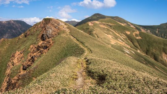
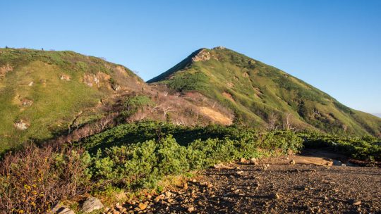
Hiked on Aug 7, 2022 . Hotaka-jinja 武尊神社 – Kengamine 剣ケ峰山 Duration: 7.5 hours Distance: 13 km Elevation change: 1058 metres Highest point: 2158 metres Start: Urami-no-taki carpark Finish: Urami-no-taki...
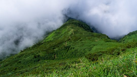
Hiked on Aug 7, 2022 . Hotaka-jinja 武尊神社 – Kengamine 剣ケ峰山 Duration: 7.5 hours Distance: 13 km Elevation change: 1058 metres Highest point: 2158 metres Start: Urami-no-taki carpark Finish: Urami-no-taki...

Outdoor Bloggers to Follow in Japan (2022) Putting together a list that celebrates the diverse international outdoor blogging community in Japan is something that I have wanted to do for some time. The reason is twofold. If there is one thing just...
Hiked on Oct 28, 2021 . Mt. Kinpu 金峰山 – Mt. Asahi-dake 朝日岳 – Odarumi-toge 大弛峠 Duration: 2 days Distance: 24.3 km Elevation change: 1089 metres Highest point: 2599 metres Start: Mizugaki-sansou Bus Stop...
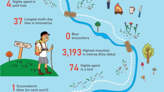
Eight and a Half Years in the Making Last week RIDGELINEIMAGES.com along with its indomitable editor-in-chief quietly chalked up the 100th hike. Yoku ganbarimashita if I might say so! Mind you these aren’t the hyakumeizan (100 top mountains) but...
Hiked on Jul 20, 2021 . Tsubame Onsen 燕温泉線 – Mt. Myoko 妙高山 – Mt. Hiuchi 火打山 Duration: 3 days Distance: 24.3 km Elevation change: 1292 metres Highest point: 2462 metres Start: Tsubame Onsen Bus Stop...

A Beginner’s Guide to Climbing Some of Japan’s Most Iconic Mountains Hiking guidebooks targeted at foreign audiences in Japan are such rare beasts that new releases are much anticipated. This time it’s Lonely Planet’s turn to return to the...
Hiked on Sep 30, 2020 . Wada Hut 和田小屋 – Kaguragamine 神楽ヶ峰 Duration: 8 hours Distance: 13.9 km Elevation change: 925 metres Highest point: 2145 metres Start: Carpark below Wada Hut Finish: Carpark below...
Hiked on Aug 19, 2020 . Komanogoya 駒ノ小屋 – Chumon-dake 中門岳 Duration: 8 hours Distance: 17.6 km Elevation change: 1233 metres Highest point: 2133 metres Start: Mitori Auto Campground Finish: Mitori Auto...
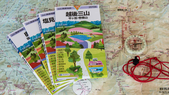
The Low-Down on Japanese Hiking Maps The map images and contents of this article have been obtained with the permission of the publisher (株式会社昭文社 Shobunsha Publications, Inc.). Writing about topographic maps i.e. a map which uses elevation contours...
Hiked on Oct 28, 2019 Aug 15, 2021 . Makihatayama Refuge Hut 巻機山避難小屋 – Mt. Makihata 巻機山 Duration: 2 days Distance: 16.3 km Elevation change: 1372 metres Highest point: 1967 metres Start: Shimizu...
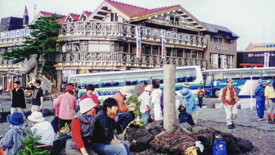
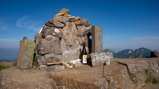
Recollections from my First Hyakumeizan It’s been 19 years since I first climbed Japan’s most iconic peak, so this Mountain Day I thought it fitting to wind back the clock and revisit my first Nihon Hyakumeizan—or 100 Famous Japanese Mountain. ...
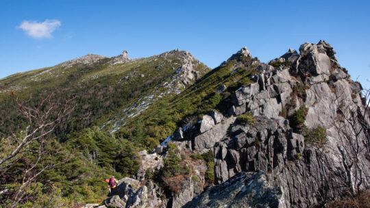
Hiked on Jul 25, 2019 . Mt. Senmai-dake 千枚岳 – Mt. Warusawa 悪沢岳 – Mt. Eboshi 烏帽子岳 Duration: 5 days Distance: 29.1 km Elevation change: 2021 metres Highest point: 3141 metres Start: Sawarajima Lodge...
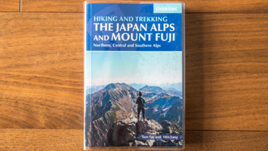
Guidebook to the Magnificent Japan Alps It would seem the only thing rarer than an albino dodo bird, scoring an albatross in golf or stumbling upon a Freshness Burger outlet in Tokyo is an English-language guidebook dedicated to Japan’s mountains...
Japan’s Most Prominent Peaks For better or worse, Kyuya Fukada’s 1964 best seller “100 Famous Japanese Mountains” (日本百名山 Nihon Hyaku-meizan) has had a profound influence on modern alpinism in Japan. It has led to a decades long hiking boom...
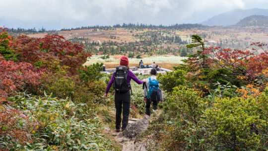
Hiked on Oct 28, 2018 . Okinomimi オキノ耳 – Mt. Mantaro 万太郎山 – Mt. Tairappyou 平標山 Duration: 3 days Distance: 25.7 km Elevation change: 1363 metres Highest point: 2026 metres Start: Doai Station (Joetsu...
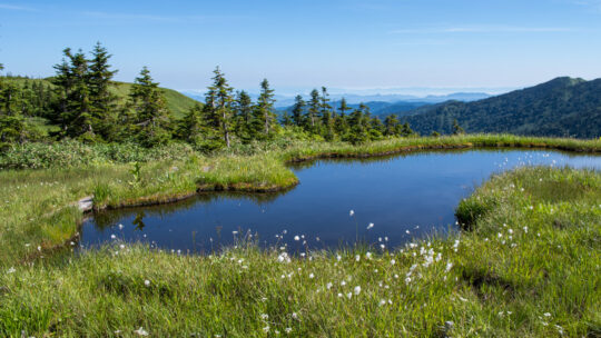
Hiked on Oct 2, 2018 . Lake Oze 尾瀬沼 – Mt. Hiuchigatake 燧ヶ岳 – Mt. Shibutsu 至仏山 Duration: 3 days Distance: 32.4 km Elevation change: 1166 metres Highest point: 2356 metres Start: Oshimizu Bus Stop ...