A Beginner’s Guide to Climbing Some of Japan’s Most Iconic Mountains
Hiking guidebooks targeted at foreign audiences in Japan are such rare beasts that new releases are much anticipated. This time it’s Lonely Planet’s turn to return to the fold after more than a decade in the wilderness – the long out of print second edition of Hiking in Japan hails from 2009. Rather than release a third iteration of this popular and well-thumbed title which might have been an obvious choice they have instead directed their efforts into 60-day hike offerings titled *Best Day Walks Japan. Of the original writing trio only, New Zealander Craig McLachlan returns joined by Tokyo based travel writer Rebecca Milner and writer and novelist Ray Bartlett who calls Cape Cod home.
Let’s begin by addressing the 800-pound-gorilla in the room. A criticism I had of the previous Hiking in Japan guidebook was it contained information that was more than three years out of date at the time of publication. This time in contrast I hoped for a freshly minted and up to date guide. The first indication that this wasn’t going to be the case is there is no mention of COVID-19, you might say a slight oversight as it has been in Japan since January 2020 and the book’s publication date is March 2021. Prior to that Typhoon Hagibis in October 2019 caused widespread destruction across large swathes of Japan resulting in damage to many hiking trails. Given the conspicuous omission of these two major events, leads me to one of two possibilities the authors have been living in an alternate reality or Lonely Planet have insanely early lead times or could have something to do with the company’s recent acquisition by American media behemoth Red Ventures. Having said that the guidebook focuses on popular trails meaning the contents are for the most part kosher.
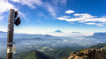
The hikes are divided into eight geographic regions stretching across the four main islands of the archipelago. Unfortunately, Okinawa Prefecture doesn’t get a guernsey this time. On the main island of Honshu, the regions include Tokyo, Mt. Fuji & around, Japan Alps & Central Honshu, Kansai, Hiroshima & Western Honshu, and Tohoku. It includes 20 peaks from mountaineer and author Kyūya Fukada’s 100 Famous Japanese Mountains. The introductory chapters cover the essentials of hiking in Japan, must see spots and it’s nice to see families haven’t been forgotten with specific tips for navigating a hiking holiday with little ones in tow. This is followed by an overview of the landscape, geology, flora & fauna, National Parks system and history and culture of alpinism in Japan. The start of each region also includes a rundown of nearby cities, best times to visit, transport, accommodation, and local festivals.
In contrast to its predecessor the typesetting, graphic elements, and layout has a modern feel making it easy to take in important points with plenty of colour photos. It should be noted however the lion’s share is drawn from stock photo agencies and it would be good to see more taken from a first-hand perspective. Call me old-school, but ‘authentic’ photos shot by the authors themselves as they walked these mountain trails is far preferable to generic stock imagery. In Wes Lang’s review on Hiking in Japan he reports that two of the stock images aren’t related places found on the hikes.
Anyway, let’s dive into the nitty-gritty to see how this long-awaited title stacks up with real world hiking in Japan starting with the book’s central premise, that is day walks with an emphasis on ‘easy’ escapes into nature. The title seems somewhat a stretch given that several of the 60 hikes aren’t particularly suited to day outings for example Mt. Fuji, Oze, Dewa Sanzan, Tateyama, Senjō-ga-take and Hakusan (or not at least without your own wheels) and naturally the 88 sacred temples pilgrimage taking upwards of 40 days to complete. Most however are well considered and cater to a range of hiking abilities from casual day hikers to more experienced adventure-seekers. For each region, the authors also highlight five additional hikes (40 in total) worth considering. It is recommended staying the night before in regional centres for example Kawaguchiko and Matsumoto to connect with early morning public transport services.
A goal for any hiking guidebook should be to help readers answer two questions. Do I want to do this hike? And do I have all the reliable information I need to do this hike safely? The latter being of foremost importance. Each hike in the guidebook specifies the duration, difficulty, distance, and start/end along with type of terrain you’ll encounter. It would also be good to see the elevation change with a profile graph, helpful for grasping the difficulty at a glance. Alongside this information is a simple coloured trail map annotated with place names in English and numbered according to the route description for quick reference. For whatever reason a number of trail maps such as Oku-Nikkō Marsh and Sandan-kyō have the north compass point orientating south making it awkward to square up with paper topo maps. Also, while the full-page regional maps provide a nice overview the smaller (non-topographic) trail maps have limited detail so apart from the shortest of day walks it’s recommend carrying a Yama to Kōgen map for each area or downloading their Yama to Kōgen Chizu Hōdai app which includes all their online maps for 400 yen per month. The 2021 edition Yama to Kōgen Chizu includes free digital map access corresponding to the paper map you purchased.
One point worth touching on are the difficultly ratings. I understand it’s completely arbitrary how mountains are graded, even so some appear a bit wonky. For example, Daimonji-yama and Nantai-san are both rated moderate, it takes about one hour to reach the summit of Daimonji-yama in contrast Nantai-san is a 3.5-hour slog with a 1,200-metre elevation change and then Shibutsu-san is Moderate-hard where the elevation change is only 800 metres. At the very least Nantai-san’s rating should be upped. As remarked on above the lack of info on elevation gain makes it hard to judge how difficult the hikes are.
Along with the ‘getting there’ and ‘starting point’ info the route descriptions are for the most part sufficiently detailed with reminders to fill out the trail logbook, trail conditions, and dangerous parts. Titbits of info draw attention to the culture, local history, and natural features. I particularly liked the ‘take a break’ section for some top spots to grab a cup of freshly brewed coffee, a cold frothy one, local delicacies or nearest onsen or ashi-yu (foot bath) – essential after a long day out on the trail. However, missing from the route descriptions and maps are locations of mizu-ba (water sources) or suggestions as to where to find them i.e., the Yama to Kōgen maps. For those of us that carry a handheld GPS device it would also be helpful if the authors could make available their GPX files at the Lonely Planet website like what Cicerone does with their trekking guides invaluable when the weather turns for the worst and visibility drops to zippo.
Given the prevalence nowadays of hikers using their smartphones for navigation, just about every Tom, Mari, and Taro relies on them out on the trail, it would be nice to see a run through of the best GPS apps to check the latest trail conditions and weather forecasts such as YAMAP, Windy.com and Geographica. In a similar vein hiking comes with risks as the authors assiduously call attention to in the route descriptions thus a reference to the importance of taking out some form of mountain climbing insurance would have been a wise idea – five of the hikes include 3,000 metre class mountains and another just shy of the mark. One final note regarding Hakusan since July 1, 2017 hikers have been required to submit a tozantodoke (intention to climb form) or risk being fined 50,000 yen.
So, do I recommend buying this guidebook? You might be surprised, but yes despite the tough love critique. I just feel it falls somewhat short of the gold standard trekking guide struck by rival Cicerone Press – Hiking and Trekking in the Japan Alps and Mount Fuji. Nonetheless, most of the information is spot on. Best Day Hikes Japan might best be described as a ‘lite’ version of Lonely Planet’s original Hiking in Japan guide – though not weight wise as it hits the scales at 500 grams! Not to say it’s a bad thing in fact the improved layout such as the numbered route description makes it easy to hone in on the important stuff at a glance. For hiking newbies, it’s a great starter volume and for the die-hard hiking brigade it offers some worthwhile suggestions and is practical reading for anyone embarking on a hike in Japan.
*In the US the book is published as Best Day Hikes Japan (March 23, 2021).
Best Day Walks Japan – Easy Escapes into Nature
by Ray Bartlett, Craig McLachlan, and Rebecca Milner
224 pages. Lonely Planet. ¥2,430.
Publication date: March 1, 2021
Available for purchase here.