Where to Hike as a Family in the Greater Tokyo Area
Hiking with children is a great way to get them connected to the outdoors and enjoy nature but knowing exactly where to go can be a challenge. Thankfully the Greater Tokyo Area has plenty of excellent well-maintained trails catering to all age ranges and abilities. The following hikes are well worth a look-see if you’re needing inspiration. They are skewed more to the lesser-known than the predictable likes of Mount Takao. Hikes rated as ‘one star’ are generally flat with little elevation gain suitable for younger elementary school aged children while those rated as ‘two stars’ are a bit tougher, have some short steep sections and would suit families with previous hiking experience.
Check out our comprehensive guide to mountains in the Kanto Region.
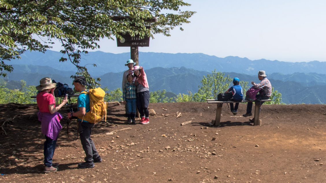
Mount Tenran 天覧山
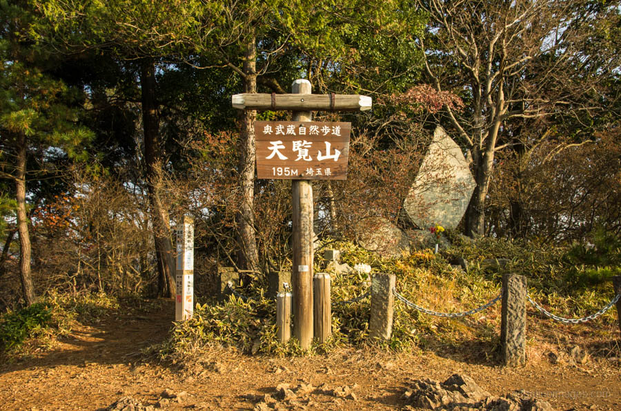
Mount Tenran could well be described as hiking with ease. The hike starts out near Hanno Station on the Seibu Ikebukuro Line only an hour from central Tokyo. The mountain has a low elevation under 200 metres making it a compelling choice for families with younger children. First point of call is heading to the Nonin-ji Temple a 20-minute walk from the station. The trail up to Mt. Tenran skirts around the temple taking you past a rest area before popping out at an observation platform which on clear days provides spectacular views towards Fuji san and the Tanzawa mountains. The full course is 9 kilometres and an alternative return option is via the Okumusashi Nature Path across to Koma Station.
Distance: 7.6 km
Elevation change: 95 metres
Highest point: 195 metres
Difficulty:
Start: Hanno Station (Seibu Ikebukuro Line)
Finish: Hanno Station (Seibu Ikebukuro Line)
Map: Yama to Kogen Chizu 山と高原地図 [No.23 奥武蔵・秩父 OKUMUSASHI·CHICHIBU]
Tenguno Falls 天狗の滝
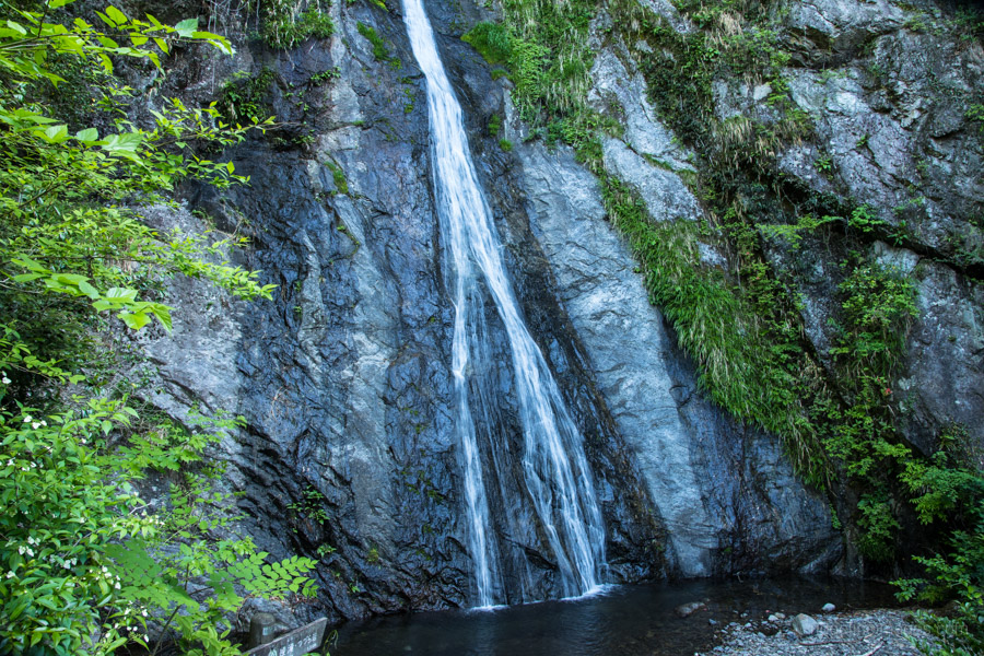
Hinohara Village in western Tokyo has nature in abundance and this hike is a good case in point. The Tenguno Falls is one of three waterfalls which track along the pristine waters of the Senzoku River. These falls are relatively secluded and make a great place to get back to nature near Tokyo. From the Senzoku bus stop it takes around 30 minutes to reach the first waterfall the Kotengunotaki. A tad further along brings you the soaring 38 metre high Tenguno Falls. Kick back and enjoy this gently flowing fall which divides in the middle. The final waterfall in the series is the Aya Falls which sits next to a small shrine and some picnic tables making a perfect lunch setting. For a round trip to the Aya Falls allow for two and half hours.
Distance: 3 km
Elevation change: 236 metres
Highest point: 526 metres
Difficulty:
Start: Senzoku bus stop
Finish: Senzoku bus stop
Map: Yama to Kogen Chizu 山と高原地図 [No.25 奥多摩 OKUTAMA]
Odashirogahara Marshland 小田代原
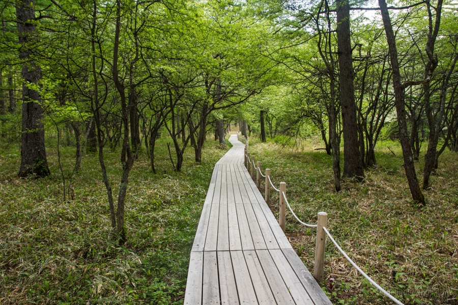
Coveted in natural beauty, the Odashirogahara Marshland set above Lake Chuzenji in Nikko is a wonderful place to enjoy a quiet escape. From Nikko Station hop on a Yumoto Onsen bound bus and get off at the Ryuzu Falls. The most direct route passes through the Senjogahara Marsh but if you have a little more time heading via the Odashirogahara Marshland is worth the extra effort. The trail makes use of a network of elevated boardwalks which help protect the fragile ecosystem. The hike is mostly flat with lots of ponds, waterfalls and restful expanses of greenery to enjoy.
Distance: 10.4 km
Elevation change: 120 metres
Highest point: 1520 metres
Difficulty:
Start: Ryuzu-no-taki Bus Stop
Finish: Yumoto Onsen Bus Stop
Map: Yama to Kogen Chizu 山と高原地図 [No.13 日光 NIKKO]
Irikawa Gorge 入川渓谷
The Irikawa Valley in Chichibu, Saitama Prefecture is one of the most scenic trails around Tokyo. Not only is great for beginners but its beauty and unique nature will entertain even the most experienced hikers. A slight drawback however is getting to the trail head as it takes over 3 hours from central Tokyo. The trail follows a disbanded railway originally used for transporting logs and with only a slight incline makes it suitable for families and senior hikers alike. The hike ends at the confluence of the Irikawa and Arakawa Rivers and nearby is a monument that commemorates the starting point of 173 km long Arakawa River. At a steady pace it should take about 90 minutes to reach this point. After taking a lunch break it’s simply a matter of retracing your steps all the way back to the bus stop.
Distance: 12.3 km
Elevation change: 290 metres
Highest point: 920 metres
Difficulty:
Start: Kawamata bus stop
Finish: Kawamata bus stop
Map: Yama to Kogen Chizu 山と高原地図 [No.27 雲取山・両神山 KUMOTORI-YAMA·RYOKAMI-SAN]
Mount Sengenrei 浅間嶺
Another hike in Hinohara Village worth considering is Mount Sengenrei which is nice to combine with a side trip to the Hossawa Falls. The falls are an easy 10-minute walk Hossawa no taki iriguchi bus stop. After taking in the delightful cascades return to the road and turn left where there is a sign pointing towards Mt. Sengenrei. The hike passes a historic homestead as you gradually climb up to the summit. Have your lunch as you watch over several famous Okutama peaks including Mt. Odake and Mt. Gozenyama. From the summit it takes around 50-minutes to reach the Kamigawanori bus stop for the return trip to Musashi-Itsukaichi Station.
Distance: 7.8 km
Elevation change: 623 metres
Highest point: 903 metres
Difficulty:
Start: Hossawa no taki iriguchi Bus Stop
Finish: Kamigawanori Bus Stop
Map: Yama to Kogen Chizu 山と高原地図 [No.25 奥多摩 OKUTAMA]
Mount Hodosan 宝登山
A pleasant family friendly hike is up Mount Hodosan in Saitama Prefecture which is close by Nagatoro Station along the Chichibu Main Line. On the way up ride the Hodosan Ropeway to the upper station where it’s a leisurely 10-minute walk to the summit. Expect to be whisked back in time as this ropeway holds the distinction of running the oldest aerial lift cabins (near on 60 years old) still used in the Kanto region. In late January to mid-February the fragrant yellow flowers of the Robai or wintersweet trees bloom and in autumn it’s a popular spot to watch the changing leaf colours. On the way down the trail passes a shrine and the Small Animal Zoo as it weaves its way back to the lower terminal building.
Distance: 6.2 km
Elevation change: 347 metres
Highest point: 497 metres
Difficulty:
Start: Nagatoro Station (Chichibu Main Line)
Finish: Nagatoro Station (Chichibu Main Line)
Map: Yama to Kogen Chizu 山と高原地図 [No.23 奥武蔵・秩父 OKUMUSASHI·CHICHIBU]


