Why the Garmin GPSMAP 67 is a Game-Changer
There has always been a compelling argument for carrying a stand-alone GPS device, whether it be a smartwatch or a handheld unit. These dedicated devices offer distinct advantages in terms of durability, accuracy, and battery life over smartphones. Features such as TracBack, which allows you to navigate back along the previously recorded track, are worth their weight in gold. The release of the Garmin GPSMAP 67 last year further strengthens this argument, making it a sound choice for anyone in need of a dependable and feature-packed handheld GPS. Read on to discover what makes this device a game-changer and sets it apart as the best-performing handheld GPS currently available…
Practicalities
A common question I hear is: Why bother with a stand-alone GPS receiver when an iPhone or Android smartphone seems sufficient? While this is partly true, especially regarding navigational capabilities, the iPhone 15 Pro and quite a few flagship Android models now support dual-frequency or “multi-band” GPS, receiving two signals from each satellite system. This feature allows for more consistent tracklogs and improved positioning in challenging environments. However, in real-world applications, their accuracy can vary widely.
In essence, it all boils down to redundancy—the wisdom of not putting all your eggs in one basket. Unlike rugged stand-alone GPS devices, smartphones are delicate and prone to damage, particularly in challenging outdoor conditions like dropping them in a river or exposure to rain and snow. This is also another reason I choose to lug around a relatively heavy Pentax K-3 Mark III. Besides taking far better photos compared to smartphones, it ensures that if my phone were out of action, I wouldn’t find myself in a pickle.
For the past eight years, I’ve relied on a Garmin Oregon 600t, and it has served me well. However, both visually and functionally, it’s now showing its age, given its release in January 2013. Over the past year, the rubber sleeve on the back cover peeled off, making it susceptible to water ingress. More concerning, during my 5-day Okuchichibu Grand Traverse, the screen froze. Although this had occasionally happened before and was usually fixed by taking out and replacing the batteries, this time it proved more stubborn. When I attempted to navigate to a track using “Where To?” it resulted in a blank screen with only the directional pointer arrow. While everything else appeared to be functioning properly, the topographic map wouldn’t display.
Having abandoned hope for the release of the Oregon 800 series, I needed little persuasion that it was time to upgrade after closely examining the GPSMAP 67. It’s worth noting that Garmin also offers the GPSMAP 67i version, which features inReach, providing global two-way messaging via the Iridium satellite network, live tracking, and emergency SOS functionality. However, for these features, an active inReach subscription is required, which adds to the running costs.
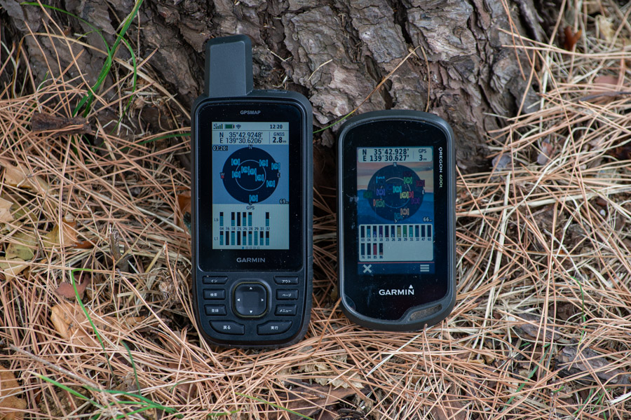
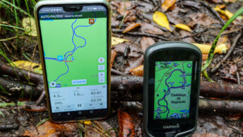
Garmin GPSMAP 67 and Oregon 600t side-by-side.
| GPSMAP 67 | Oregon 600t | |
|---|---|---|
| Battery type | Rechargeable, built-in lithium-ion battery | 2 AA batteries |
| Battery life | Up to 180 hr. in GPS mode / 840 hr. in expedition mode | Up to 16 hr. in GPS mode |
| Tracking | GPS, GLONASS, Galileo, QZSS, BeiDou, and *IRNSS | GPS and GLONASS |
| Antenna | Quad helix | Patch |
| Waypoints | 10,000 | 10,000 |
| Protection | IPX7; MIL-STD-810 (thermal, shock, water) | IPX7 |
| Internal memory | 16 GB | 300 MB |
| External memory | 32 GB max microSD card | 32 GB max microSD card |
| Display | 240 x 400 pixels (transflective color TFT) | 240 x 400 pixels (transflective color TFT) |
| Display size | 3″ diag (7.6 cm) | 3″ diag (7.6 cm) |
| Touch screen | No | Yes |
| Sensors | Barometric altimeter, 3-axis compass | Barometric altimeter, 3-axis compass |
| Operating temperature range | From -20° to 60°C | From -20º to 70ºC |
| Charging temperature range | From 0° to 45°C | From 0° to 45°C |
| Interface | USB-C | mini USB |
| Dimensions | 6.2 x 16.3 x 3.5 cm | 6.1 x 11.4 x 3.3 cm |
| Weight | 230 g | 210 g (with batteries) |
| Release date | March 14, 2023 (Sep 14, 2023 JPN.) | January 7, 2013 |
*Not applicable in the case of Japan. The IRNSS regional GNSS covers the Indian region and has a radius of 1500 km around the Indian mainland.
Form Factor
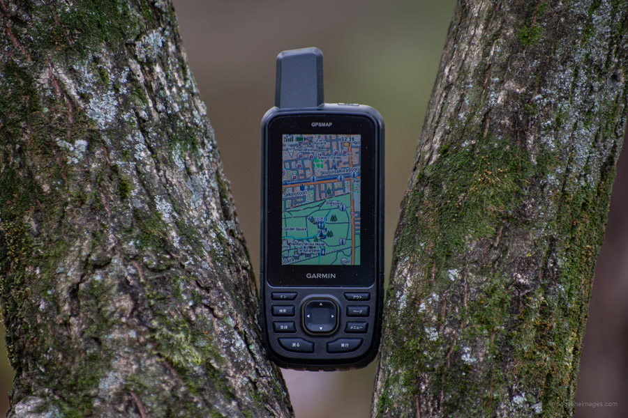
To begin with, it’s worth delving into the form factor. I’ve already had a couple of people ask me if it’s a satellite phone or a two-way radio, which I guess isn’t too surprising. I have it attached to my shoulder strap using a Garmin backpack tether, so it tends to catch people’s attention. The most noticeable difference visually between the GPSMAP 67 and my old Oregon 600t is the antenna; specifically, the GPSMAP sports a quad-helix while the Oregon has an internal patch. Quad-helix antennas seem to have marginally better performance than patch antennas, primarily due to their larger size. Apart from an additional 4 centimetres in length, the width and thickness of both devices remain similar. The screen resolution (240 x 400 pixels) and display size at 3 inches diagonally stay unchanged, and in terms of weight, the GPSMAP 67 is 20 grams heavier.
The main difference between the international edition of the GPSMAP 67 and the Japanese version lies in the rubberised buttons, which include Japanese characters instead of English. Unfortunately, the Japanese characters are finely printed, making them a tad difficult to make out. However, the unit itself can be configured to display text in English as well as nine other Asian languages. Moreover, there is a difference in the firmware edition.
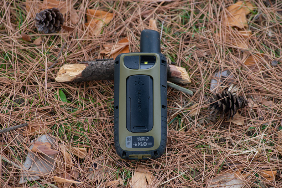
The GPSMAP 67 sports a quad-helix antenna.
Built to Last
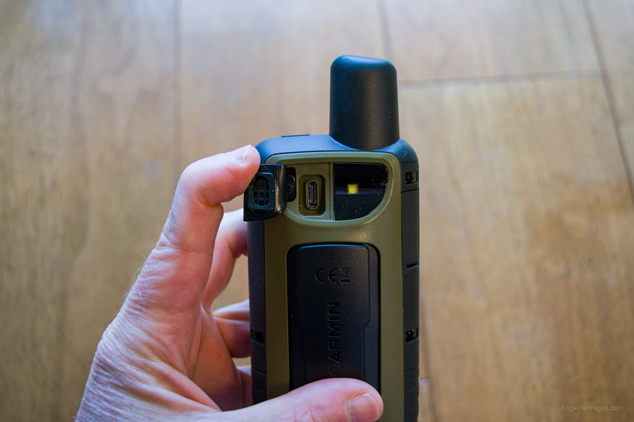
Right out of the box, the rugged construction of the GPSMAP 67 is evident, built to military standards for thermal, shock, and water resistance. It has been tested against MIL-STD-810, the U.S. Department of Defense Test Method Standard, ensuring it passes rigorous environmental conditions. Garmin specifies its operational range from -20°C to 60°C, though interestingly, the Oregon 600t was rated up to 70°C. The rubber buttons incorporate sealing components, making the device both dust-proof and water-resistant. In addition, the presence of a sealed cover on the USB-C port greatly reduces the risk of water getting inside.
The 3-inch sunlight-readable colour display is clear and crisp, even in direct sunlight. The intuitive button interface makes navigation through menus easy, even with gloved hands. This marks a significant improvement over the Oregon 600t, where the screen worked fine with thin gloves but proved ineffective with thicker ones. Even though the transflective colour TFT is made from high-impact plastic, it’s advisable to purchase a strong 9H (hardness level) screen protector to safeguard against potential damage. If you’re upgrading from a touchscreen display, such as those in the Oregon series, it takes some getting used to manoeuvring the directional pointer arrow via the rocker and resisting the instinct to reach for the screen.
Built to military standards for thermal, shock, and water resistance.
Multi-Band GNSS Support
Where the GPSMAP 67 truly shines is in its navigation capabilities. The device supports both multi-GNSS (the reception of signals from multiple satellite systems) and multi-band (the reception of signals on multiple frequency bands of a single system). These “GNSS” (Global Navigation Satellite Systems) include; GPS (US), GLONASS (Russia), Galileo (EU), QZSS or Michibiki (Japan), and BeiDou (China). It is also more adept at locking onto signals in challenging environments where a single system might struggle, providing superior accuracy and reliability. This is a significant improvement over older GPS models like the Oregon 600t, which were restricted to GPS and GLONASS (think 55 satellites vs. 118).
Additionally, the GPSMAP 67 can receive and display the latest L5 Block III satellites, routinely achieving an accuracy of 1.8 metres. While not applicable in the case of Japan, it’s worth noting that IRNSS or NavIC is another regional GNSS designed to cover the Indian region and has a radius of 1500 km around the Indian mainland.
Battery Life
This could be the decisive factor for many. With up to 180 hours in GPS mode and a whopping 840 hours in expedition mode, the GPSMAP 67 ensures you stay powered for days. Even when multi-band GNSS support is active, you can expect a battery life of at least 130 hours. This is a remarkable increase, surpassing the previous GPSMAP 66i, which offered 35 hours. Say goodbye to worries about running out of battery in the middle of nowhere, and if you ever do, the USB-C makes recharging from a power bank convenient. In contrast, the Oregon series only allowed recharging using a proprietary 2000mAh NiMH battery pack. During my 9-day Southern Alps traverse last year, I had to carry five sets of AA alkaline batteries. In that scenario, I needed an extra 250 grams of batteries on top of the Oregon 600t unit itself (156 g), totalling over 400 grams.
It would appear the battery has a similar capacity to the GPSMAP 66i, which has an internal 3100mAh lithium-ion battery. I figure this is because, using an Anker PowerCore 5000, it charged the GPSMAP 67 from 50 percent to full, depleting one but less than two battery-level indicators. So, the question arises: Why does the GPSMAP 67 have more than five times the staying power? It is mainly due to new hardware (it now uses the same GPS chip family as in the recent Garmin smartwatch devices) along with firmware tweaks to maximise the battery life. No matter how you look at it, it’s an impressive feat of engineering.
Another thing to note is that you don’t get a battery percentage metre unless it’s plugged in and charging. Although some users have reported success with the ‘Battery Widget with Automatic Charge Detection’, a Connect IQ widget, it didn’t work for me when I attempted to install it. I’ve read that Connect IQ apps usable in the international edition cannot be used in the Japanese version. To maximise battery life, it is recommended to reduce the backlight timeout and brightness and also to turn off WiFi connectivity and Bluetooth.
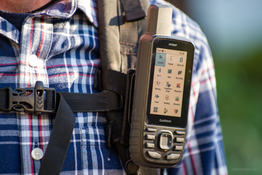
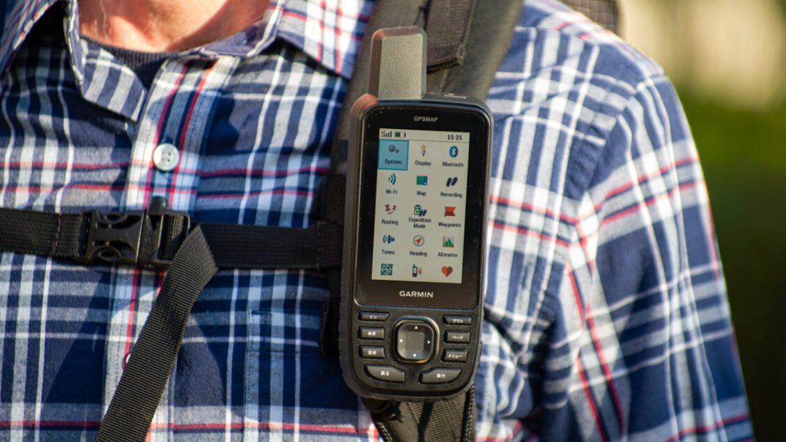
GPSMAP 67 attached to the shoulder strap using the Garmin backpack tether.
Preinstalled Maps
In the Japanese version, the preloaded TopoActive map incorporates the Japan DKG Map 2022.10 by the Geospatial Information Authority of Japan (GSI), offering a national base map at a scale of 1/2500, complete with 10-metre contour lines. Users can freely update to the latest version as new releases become available. Additionally, I’ve downloaded and installed OpenStreetMap (OSM) Japan. This can be done by copying the gmappsupp.img file into the Garmin folder on the SD card or internal memory. The English version of the OSM map data can be downloaded here. Unlike in the past, where a subscription to Garmin BirdsEye Satellite Imagery was required, now you can download satellite imagery directly to your device through a Wi-Fi connection at no extra cost.
Those looking for maps that provide course times, details about mountain huts, campsites, and water sources, along with warnings about hazardous terrain, may wish to consider the Garmin TOPO10M Plus Mountaineering Topographic Map. This digital terrain map with stylised colour coding tailored to hiking is based on the 63 maps found in the Yama to Kōgen Chizu (Maps of Mountains and Plateaus) series by Shobunsha Publications.
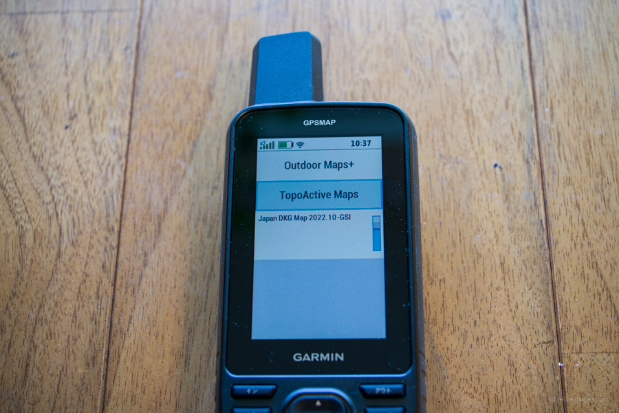
Preloaded DKG Map 2022.10-GIS TopoActive Map (Japan).
Hands-on Use
Holding the GPSMAP 67 for the first time, it exudes a premium feel. The buttons offer a satisfying tactile click when pressed, and the rubberised texture of the body adds to the secure feeling when handling the unit. Gone is the rear access cover, giving the unit a more solid and cleaner look. The SD card is now conveniently mounted on the side, protected by a rubberised cap, eliminating the need to remove the batteries for card access. The start-up time is blazingly fast, around 10 seconds, with an additional 30 to 60 seconds needed to lock onto satellite signals.
For those upgrading from earlier versions of the GPSMAP or Oregon series, the user interface remains familiar, albeit still a bit awkward, allowing users to hit the ground running. It’s a design that hasn’t seen much change over the past decade. A noteworthy addition is the ribbon across the bottom of the screen, which allows for swift scrolling through pages. The built-in LED flashlight is also nicely integrated into the back of the device.
However, if you are new to Garmin GPS handhelds, mastering its functions and settings can pose a bit of a learning curve. It requires some exploration, playing around with it, and delving into the menus to get the most out of the device. For instance, I noticed that by default, the output format was set to Fit rather than Fit and GPX. While the online owner’s manual is sufficient, there’s room for improvement. Notably, it fails to mention available display languages or whether the device can even be set to English. I had to resort to emailing the local Garmin Support Center in Japan to find this basic information out before making the purchase. The inclusion of USB-C is a welcome addition, and the charging time is great, taking around an hour to reach 50 percent. Although some users have reported issues with the device not being recognised by Windows 10, it was quickly found and synced without any problems on my Windows 11 computer.
The directional pointer, operated via the rocker, works well enough, although it can be a bit slow to get going when scrolling through maps. One aspect that remains somewhat disappointing is the screen resolution, which stands at 240 x 400 pixels—the same as the Oregon 600t released a decade ago. Having said that, the display does appear to be brighter. Here’s hoping the next Garmin GPSMAP 60 series model will feature a bumped-up resolution and an AMOLED display. Additionally, having the battery level shown in percentage terms would have been helpful without the need for a third-party app.
After taking the GPSMAP 67 on several hikes, I can affirm that it indeed lives up to the hype and represents a substantial improvement over the Oregon 600t, especially in terms of accuracy. In areas where the Oregon used to struggle or even go haywire, such as deep valleys and heavily forested areas, the GPSMAP 67 track data shows far more consistent results after uploading and examining on Ride with GPS. While it’s not perfect, it is likely to provide a better satellite fix than any other handheld outdoor GPS currently on the market.
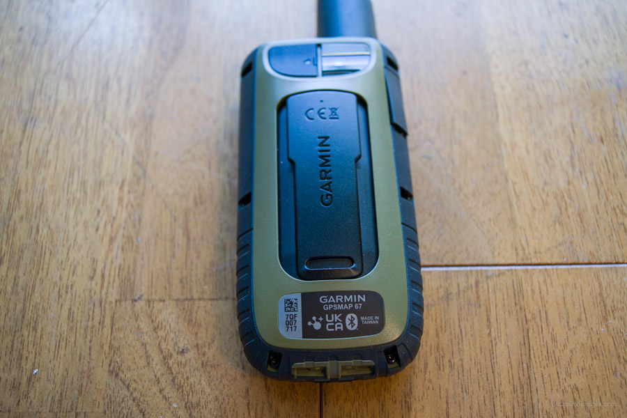
Rubberised texture of the body adds to the secure feeling when handling the unit.
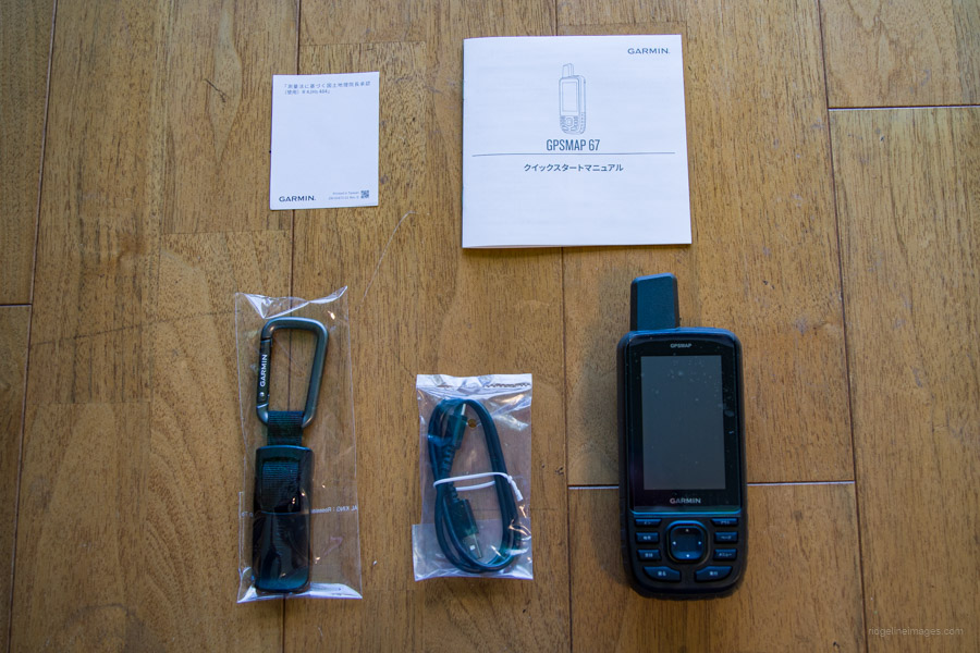
What’s in the Box
Here’s a breakdown of what’s included in the Japanese version of the Garmin GPSMAP 67:
- GPSMAP 67 handheld GPS device with internal rechargeable lithium-ion battery
- Preloaded DKG Map 2022.10-GIS TopoActive map (Japan)
- Type A to Type C USB cable
- Carabiner clip
- Quick start guide
- Important safety and product information
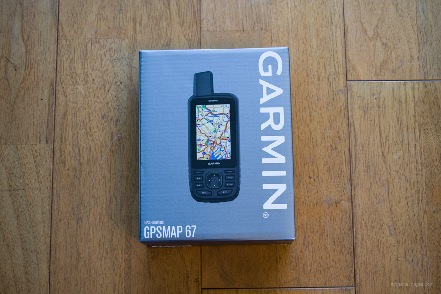
GPSMAP 67 packaging box.

BOTTOM LINE
The Garmin GPSMAP 67 stands out as a top-of-the-line GPS handheld navigator, excelling in ruggedness, precision, and feature richness. It caters to the needs of serious outdoor enthusiasts involved in activities such as hiking, cycling, geocaching, or climbing. While the device isn’t without its shortcomings, it nevertheless manages to check most of the boxes required by a modern handheld GPS device. Despite a potentially steep price tag for casual users, those prioritising reliability, performance, and, more importantly, their safety in the backcountry will find the GPSMAP 67 to be a worthwhile investment.
Where to Buy
*Garmin GPSMAP 67: 77,091 yen (Incl. tax) AMAZON JAPAN
*Garmin GPSMAP 67i: 90,727 yen (Incl. tax) AMAZON JAPAN
.
* When you use our affiliate links to make your purchase, the seller will contribute a portion of the sale to help support this site.


Nice writeup as always, David! I have a 66i so it was particularly interesting to see what has changes. The battery improvement is awesome.
It’s definitely a nice little companion and has saved me from picking a wrong trail a few times. Definitely shines on those multi-day hikes where you have to ration the smartphone power even with an external bank.
My biggest complaint is that by virtue of living in Japan not only the device costs more than the global version, but also has a firmware that significantly lags behind the rest of the world. 66i had some nasty bugs with expedition mode that took Garmin well over half a year to fix in JP firmware if memory serves. And just checking the global firmware changelog from v9.50 update back in April 2023, none of the described new features, and consequently fixes, have made it into the Japanese version, even though it has been almost a year. Pretty sad given the price point.
How do you find OSM maps compared to the preloaded ones?
Alex, thanks for the kind words! It’s good to hear you found the write-up helpful.
I totally get where you’re coming from regarding the 66i. It’s a fantastic device, but the disparity in pricing and firmware updates between regions can be frustrating. It’s unfortunate that Japanese users have to deal with these delays and missed features compared to the global version. Hopefully, Garmin addresses these issues soon.
Last week, Garmin released firmware v. 7.60 for the global version of the GPSMAP 67 and v. 6.62 for the Japanese version. Since the 67 was only released in Japan in September last year (6 months behind the rest of the world), we probably won’t see v. 7.60 here until at least July!
The preloaded TopoActive Map, I feel, is enough, though the OSM maps can be helpful, especially with the English text. It would be nice to have the Garmin TOPO10M Plus, which incorporates the Yama to Kogen Chizu, but given that I already carry the paper maps, I felt it would be overkill. The most recent firmware also updated the TopoActive Map to 2023.10-GIS, which was good to see.
Hi David, Very Good article. So good in fact, I will purchase one of these 67i units when I return to Ome from my trip here in Hakuba this week end. I assume if I use the links to the items in your article you will receive “credit” for the referral?? (GPS, Screen protector, backpack tether).
I do have a few additional questions, but I will wait until the unit arrives and take a look at things first.
I will be upgrading from my old Garmin 550T (U.S. Version) with Garmin Japan 10m Topo SD still working fine.
Hi Carl,
I’m pleased to hear that the review was helpful.
Yes, if you use the links in the article to purchase the GPS, screen protector, or backpack tether, I will receive credit for the referral.
I’m sure you’ll find the 67i a vast improvement over the 550T. Don’t hesitate to reach out with any questions once you have it in hand.
Enjoy the rest of your trip in Hakuba!
Hi David,
Thank you for this insightful review! I was wondering if there are any downsides to using the US model Garmin GPSMAP 67 or 67i in Japan. I assume it works seamlessly and that the same maps can be downloaded, but I would appreciate any insights on region-specific considerations.
Hi Clay,
Thanks for your comment and question.
Regarding the maps: Garmin Express should show a list of TopoActive maps available for download, including TopoActive Japan. However, my understanding is that the official Japan Electronic Geospatial Map (current version 2023.10) is only available on Japanese models. Another option is to use maps from OpenStreetMap.
Hi David,
Ever since you wrote this excellent review I’ve been keen to buy a Garmin GPS Map 67 and finally plan to do so but need your opinion on where to buy it. I spend most of the year from April to November in Japan where I do most of my hiking, but the rest of the year I am in Australia where I do some hiking too, and this March I’m planning to hike 2 weeks in Patagonia. So I’m wondering if I should buy the Aussie version now, or wait until I’m in Japan and buy the Japanese version. I’m also wondering whether to buy the 67i or not .. what would you do in my situation?
Hi Phil,
Thanks for reaching out with your question—it’s a good one! First, I’m glad to hear you found this review helpful, and it’s great that you’re planning to pick up a Garmin GPSMAP 67.
As for where to buy it, I’d probably lean towards the Japanese version if the majority of your hiking is in Japan. If you go this route, you could purchase it when you arrive in Japan in April. That said, if you need the device sooner for your Patagonia trip, the Australian version might be the better option.
If I were in your shoes, I’d likely forgo the 67i. For hiking in Japan, I don’t feel the inReach satellite communication is worth the extra cost, although the ability to send SOS messages or communicate when off the grid would be handy. Personally, I rely on a COCOHELI radio transmitter and my smartphone, which I feel is sufficient for my needs.
One additional point: in a previous comment, I mentioned that while Garmin Express shows a list of TopoActive maps available for free download (including TopoActive Japan), these appear to be based on OSM (OpenStreetMap) data rather than the official Japan Geospatial Information map, which comes preloaded with the Japanese version.
Thanks David for your advice that makes sense. I was leaning to waiting until I get back too. I have CocoHeli too so would skip the 67i. I’ll be sticking to popular trails in Patagonia so shouldn’t need it if I download maps on my phone in advance.