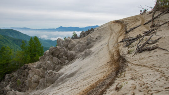
Hiked on Feb 14, 2025 . Yamanakako Panorama-dai 明神山パノラマ台 – Mt. Mikuni 三国山 – Mt. Takasasu 高指山 Duration: 4.5 hours Distance: 10.5 km Elevation change: 338 metres Highest point: 1328 metres Start: Mikuniyama Hiking Course Iriguchi Bus Stop ...
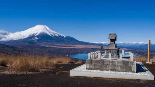
Hiked on Feb 14, 2025 . Yamanakako Panorama-dai 明神山パノラマ台 – Mt. Mikuni 三国山 – Mt. Takasasu 高指山 Duration: 4.5 hours Distance: 10.5 km Elevation change: 338 metres Highest point: 1328 metres Start: Mikuniyama Hiking Course Iriguchi Bus Stop ...
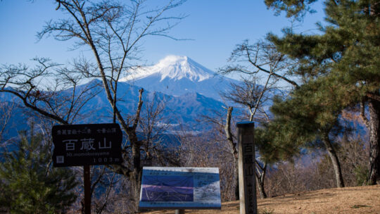
Hiked on Feb 7, 2025 . Konpira-kyu 金比羅宮 – Mt. Daidosan 大同山 – Mt. Momokurayama 百蔵山 If you wish to include neighbouring Mt. Ougiyama, you can also undertake it as a station-to-station hike starting from Torisawa Station. Duration: 4.5 hours ...
Hiked on Dec 17, 2024 . Misaka-toge 御坂峠 – Kurodake Tenbodai 黒岳展望台 – FUJIYAMA ツインテラス Duration: 6 hours Distance: 12 km Elevation change: 783 metres Highest point: 1793 metres Start: Mitsutoge Iriguchi Bus Stop Finish: Kawaguchiko Natural...
Hiked on Nov 30, 2024 . Mt. Shomureyama 聖武連山 – Mt. Nodake 能岳 – Mt. Yaeyama 八重山 Duration: 4 hours Distance: 9 km Elevation change: 265 metres Highest point: 543 metres Start: Oduku Bus Stop Finish: Ohori Bus Stop Difficulty: ...
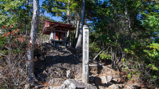
Hiked on Nov 9, 2024 . Keikan Shrine 鶏冠神社 – Roppongi-toge 六本木峠 – Marukawa-toge 丸川峠 . Duration: 6 hours Distance: 15.3 km Elevation change: 826 metres Highest point: 1716 metres Start: Ochiai bus stop Finish: Daibosatsu-toge trailhead bus...
Hiked on Nov 3, 2024 . Yunosawa-toge 湯ノ沢峠 – Mt. Okuratakamaru 大蔵高丸 – Mt. Takigoyama 滝子山 Do not attempt this hike unless you have experience in route-finding and make sure you carry a topographic map and handheld GPS device. Duration: 2 days ...
Kanto’s Autumn Blues I write this with utter exasperation over the current state of the weather. Ordinarily, I would be setting off on a multi-day autumn adventure, but now it seems I’ll have to wait until later in the week for the autumn rain...
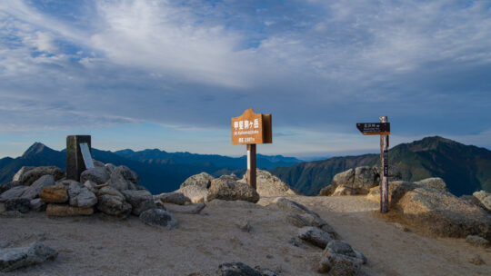
Hiked on September 24, 2024 . Ojiragawa Gorge 尾白川渓谷 – Shichijo-koya 七丈小屋 – Komagatake Shrine 駒ヶ岳神社 This is a long and demanding hike, suitable for experienced hikers. Do not attempt the Kuroto Ridge course unless you are comfortable climbing...
Hiked on May 23, 2024 . Hakushukanko Ojiro Campground 白州観光 尾白キャンプ場 – Ojiragawa Gorge 尾白川渓谷 Duration: 2 days Distance: 16.8 km Elevation change: 1046 metres Highest point: 1660 metres Start: Michi-no-Eki Hakushu bus stop Finish: Michi-no...
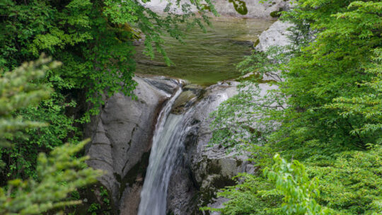
Hiked on May 22, 2024 . Chikukomagatake Shrine 竹宇駒ヶ岳神社 – Ojiragawa Gorge 尾白川渓谷 Although the Ojiragawa Gorge loop includes fixed chains, there are sections with significant exposure, so proceed with caution. Duration: 3 hours Distance: 3.8 km ...
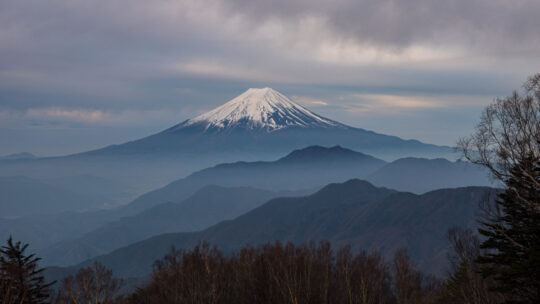
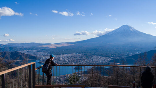
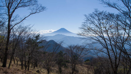
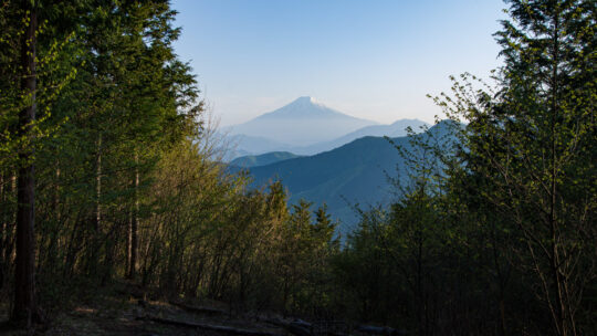
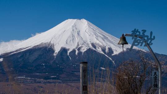
Otsuki 20: Best Fuji-san Viewpoints Being a little over an hour away by train from my local station in west Tokyo has meant I have been able to visit Otsuki City frequently over the past decade. This proximity has allowed me to climb many of its...
Hiked on May 4, 2024 . Kosuge-no-Yu 小菅の湯 – Mt. Omatei 大マテイ山 – Mt. Muko 向山 Do not attempt this hike unless you have experience in route-finding and make sure you carry a topographic map and handheld GPS device. Duration: 2 days Distance: 22.8...
Hiked on Apr 13, 2024 . Kamimagi Shrine 上真木大神社 – Mt. Oiwa 大岩山 – Mt. Hanasaki 花咲山 Duration: 3.5 hours Distance: 6.7 km Elevation change: 247 metres Highest point: 750 metres Start: Kamimagi bus stop Finish: Otsuki Station (JR Chuo Main...
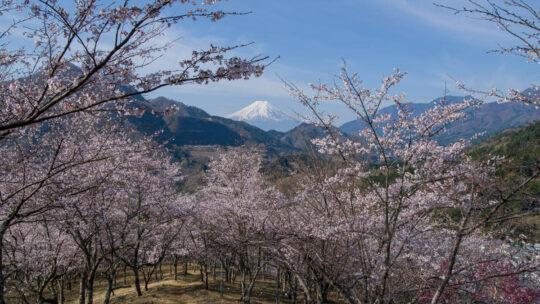
Hiked on Apr 2, 2024 . Mt. Ariyama 蟻山 – Mt. Fuji viewpoint 富士山展望台 – Mt. Tenshin 天神山 Duration: 5 hours Distance: 10.5 km Elevation change: 246 metres Highest point: 713 metres Start: Tsurushi Station (Fujikyuko Line) Finish: Higashi...
Hiked on Mar 27, 2024 . Fudo-yu 不動湯 – Ozasu-toge 大榷首峠 – Mt. Takazasu 高座山 Duration: 5.5 hours Distance: 14.4 km Elevation change: 848 metres Highest point: 1598 metres Start: Shimoyoshida Station (Fujikyuko Line) Finish: Oshinomura Yakuba...
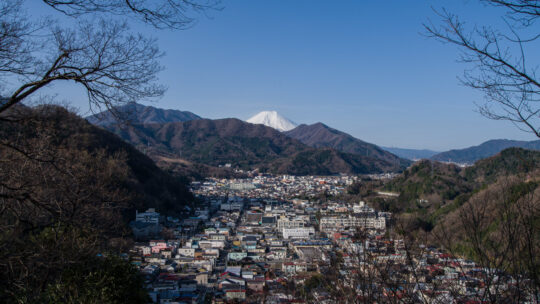
Hiked on Jan 22, 2024 . Sojogamine 相定ヶ峰 – Mt. Kurami 倉見山 – Dooyama Park 堂尾山公園 Duration: 4 hours Distance: 9.8 km Elevation change: 695 metres Highest point: 1256 metres Start: Higashi-Katsura Station (Fujikyuko Line) Finish: Kotobuki...