Route Notes, Accommodation & Logistics
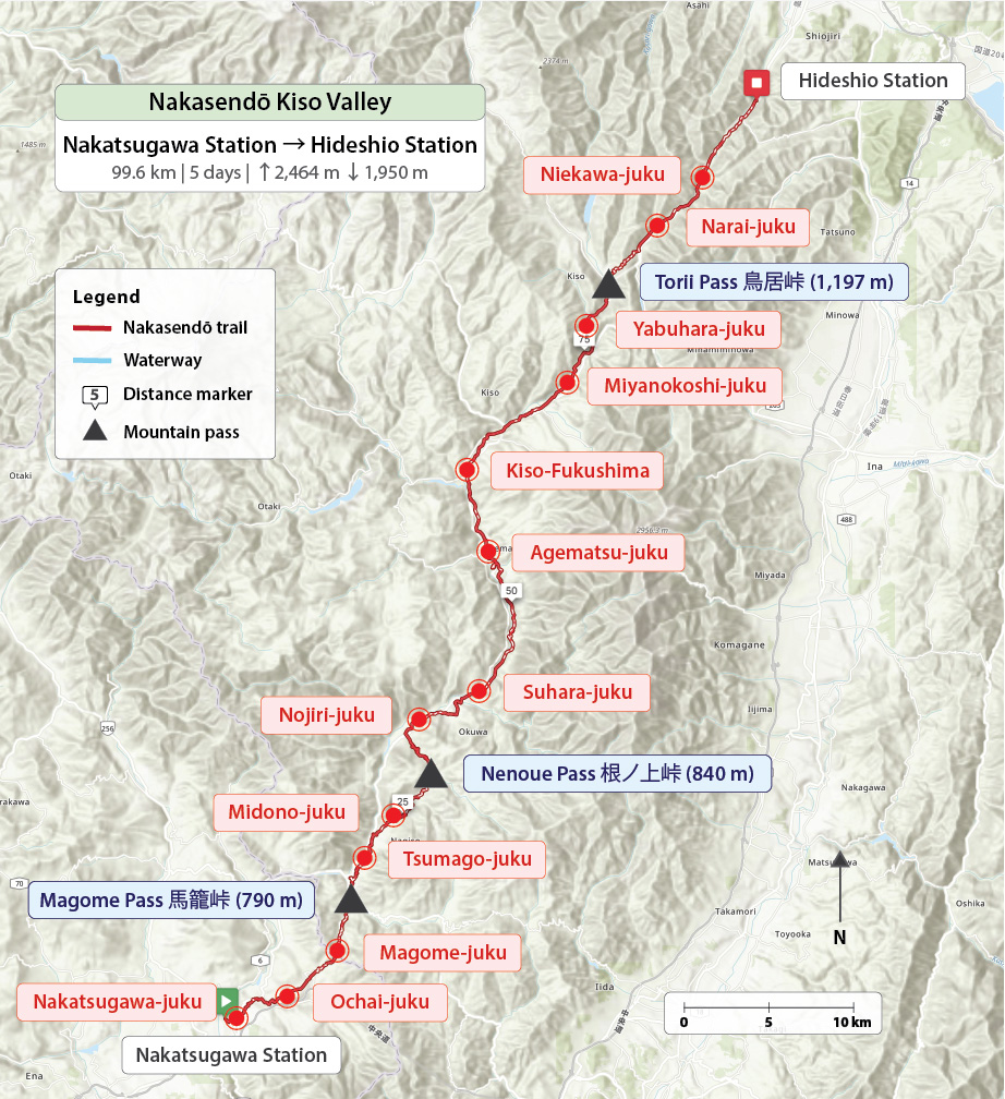
As someone who naturally gravitates towards longer, multi-day walks, the Nakasendō had long been on my radar – not as a quick day trip between Magome and Tsumago, but as a continuous walk through the Kiso Valley. That opportunity finally came in April 2026, when I spent five days walking from Nakatsugawa Station (Gifu) to Hideshio Station (Nagano), covering roughly 100 kilometres and passing through thirteen post towns.
Genuinely practical information for anyone planning more than the standard Magome–Tsumago day walk or shorter sections such as the Torii Pass crossing is surprisingly hard to find. The reader enquiries I’ve received this year only confirmed that and, in part, pushed me to finally walk the full route myself. What follows is a single, comprehensive 72-page resource based on that experience.
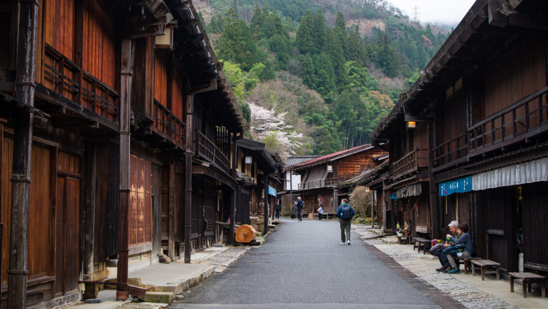
Nakasendō Ochiai-juku.
In This Post
About This Guide
Trip Snapshot
The Nakasendō Kiso Valley Map
Who Is This Guide For?
What It Cost Me to Do the Walk Independently
What the Itinerary Covers
What’s Included in the Downloadable Guide
Download the Guide
Bespoke Route Planning
Frequently Asked Questions
About This Guide
While there’s plenty of material online, much of it focuses on only a small part of the route. A handful of blogs do cover this same stretch, but typically in pieces spread across different seasons or even several years, while many tourism websites focus primarily on guided tours. That’s a perfectly understandable way to approach the Nakasendō, but it creates a very different experience from walking the route over consecutive days and requires different planning.
Most resources naturally concentrate on Magome, Tsumago, and Narai – the most photogenic sections of the trail. Stitching the rest together into a reliable multi-day itinerary, with joined-up logistics, accommodation, and navigation, takes far more work than it should. This guide is designed to change that.
It presents a complete five-day walking itinerary through the Kiso Valley, covering the best-known post towns while also passing through quieter sections that most visitors never reach.
Each day includes detailed route notes, key waypoints, photos, elevation profiles, and accommodation suggestions. Downloadable GPX and KML files are also provided for use with apps such as AllTrails, Komoot, and Ride with GPS, or for uploading to GPS devices for accurate on-trail navigation.
In addition to the route itself, the guide covers practical details that are often overlooked: whether to stay in Nakatsugawa the night before or travel in on the day, how best to use the JR Chūō Line running through the valley, luggage-forwarding options, seasonal considerations, recent trail updates, and plenty of tips to help you get the most out of the walk.
Ichikokutochi Tateba Chaya, a 250-year-old rest house.
Trip Snapshot
| Day | Route | Distance | Elevation | Highlights |
|---|---|---|---|---|
| 1 | Nakatsugawa Station → Tsumago-juku | 18 km | +656 / −485 m | Forest trails over the Magome Pass linking two beautifully preserved post towns. |
| 2 | Tsumago-juku → Nojiri-juku | 17.1 km | +562 / −496 m | Quiet rural valleys and lesser-walked stretches along the Yogawa-michi. |
| 3 | Nojiri-juku → Kiso-Fukushima | 29.5 km | +593 / −367 m | Long valley walk with optional rail shortcut and a detour to Nezame-no-toko Gorge. |
| 4 | Kiso-Fukushima → Narai-juku | 21.9 km | +544 / −369 m | Climb over Torii Pass (1,197 m), the highest point on the Nakasendō, descending into Narai. |
| 5 | Narai-juku → Hideshio Station | 13.1 km | +109 / −233 m | Gentle finish through Kiso-Hirasawa’s lacquerware district and the widening valley towards Shiojiri. |
| Total | ~100 km | +2,464 m / −1,950 m | Five days walking the heart of the Kiso Valley. |
*The embedded map above shows the full five-day route with key waypoints. Purchasers of the guide receive direct GPX and KML downloads, including full waypoint data – normally a premium RWGPS feature.
The Nakasendō Kiso Valley Map
![]()
Five-day elevation profile: Nakatsugawa to Hideshio.
Who Is This Guide For?
This guide is designed for independent walkers with moderate hiking experience who want to explore the Nakasendō beyond the standard tourist sections, without relying on a guide or organised tour.
It’s best suited to those who are comfortable navigating day-to-day logistics, carrying what they need between stops, and walking for consecutive days through a mix of well-preserved post towns and quieter rural stretches.
If you’re looking to experience the route as a continuous journey through the Kiso Valley rather than as a series of isolated highlights, this guide was created to fill that gap.
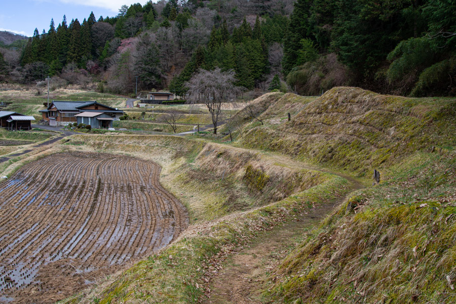
Terraced rice fields, Yogawa-michi Trail.
What It Cost Me to Do the Walk Independently
The Nakasendō can be done on a surprisingly modest budget if you’re willing to be flexible with accommodation. Here’s what I actually spent on my April 2026 walk as a rough guide:
Accommodation (per person)
• Nakatsugawa (2 nights, budget hotel, no meals): ¥7,310 × 2 = ¥14,620
• Nojiri-juku (ryokan, dinner and breakfast included): ¥11,400
• Kiso-Fukushima (minshuku, no meals): ¥5,500
• Torii Pass refuge hut (free – I stayed here rather than continuing to Narai-juku, though most walkers will overnight in Narai itself)
Meals
On days without set meals, lunch and dinner came to roughly ¥1,500 each. I carried snacks between towns to keep costs down.
Transport
• Tokyo to Nakatsugawa: ¥9,380
• Hideshio to Tokyo: ¥5,760
Rough total: approximately ¥55,000–¥60,000 for five days including transport – or around ¥45,000 without travel costs.
This sits firmly at the budget end of what’s possible. Staying in a traditional ryokan with dinner and breakfast included every night would push costs considerably higher – the accommodation guide inside the PDF covers the full range of options from budget to splurge.
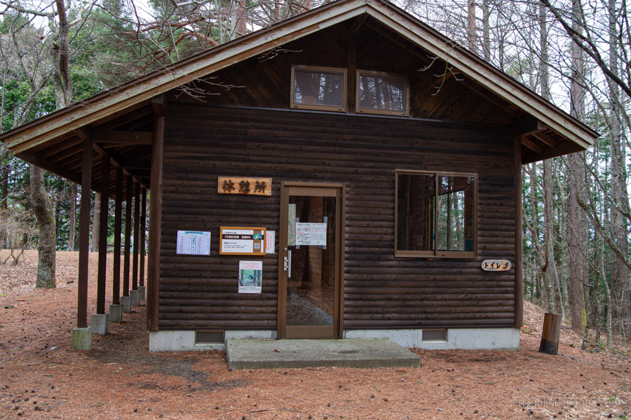
Unmanned refuge hut near Torii Pass.
What the Itinerary Covers
This itinerary follows a five-day walking schedule along the historic Nakasendō through the Kiso Valley. Daily stages range from easy–moderate to strenuous, and several stages include sustained climbs over low mountain passes and long stretches between towns. Along the way, the route links a series of Edo-period post towns (shukuba-machi), some beautifully preserved and others now quiet rural settlements.
From Day 3 onwards, the historic trail intersects more frequently with modern roads. Many walkers choose to use the local JR Chūō Line to bypass the longest highway sections, and this guide outlines those optional rail-assisted alternatives. These allow you to shorten certain days while still experiencing the most scenic and historically rewarding parts of the route.
What’s Included in the Downloadable Guide
In brief, the guide includes:
• Detailed day-by-day route descriptions
• GPX and KML track files for all five days, plus a combined Days 1–5 track
• Elevation profiles, key waypoints, and route maps for each day
• Suggested accommodation options for each overnight stop
• Transport guidance to and from the trail, including Shinkansen connections, bus stops, and fares
• Notes on detours and current trail conditions
• Practical tips covering hiking etiquette, luggage forwarding (takkyūbin), camping options, and more
This guide is the result of five days on the trail – blisters included – and a good deal of time spent refining routes, maps, and logistics afterwards. As always, I try to keep the majority of my content freely accessible, but for more in-depth resources like this, I ask for a small contribution to help support the work that goes into creating them.
→ The Nakasendō Kiso Valley – Sample Pages (PDF)
Download the Guide
72 pages · five days · GPX & KML tracks · field-verified April 2026
Price: 3 Ko-fi ¥1,500
Instant download
One-time payment. No Ko-fi account required.
The guide is delivered as a PDF with direct download links to all GPX track files included inside. A sample is available above before purchasing. Ko-fi purchases are non-refundable.
The paperback edition is available on Amazon Japan for ¥1,980 (incl. tax)
Get the Paperback on Amazon JapanShips within Japan and internationally via Amazon.
Bespoke Route Planning
Not everyone wants to follow a fixed itinerary. If you’re working around limited time, prefer a slower pace, want to focus on specific sections, or have particular accommodation preferences, a tailored plan can make more sense than trying to adapt a standard guide.
I offer customised itinerary planning for independent hikers walking the Nakasendō and other routes in the Kiso Valley, as well as across the wider Kanto and Chūbu regions. Plans are built around your pace and experience, with accommodation suggestions to match your budget and style.
If you’ve already picked up the guide but want to adapt it to your schedule, I’m happy to help.
If you’d like to talk through your plans, feel free to get in touch.
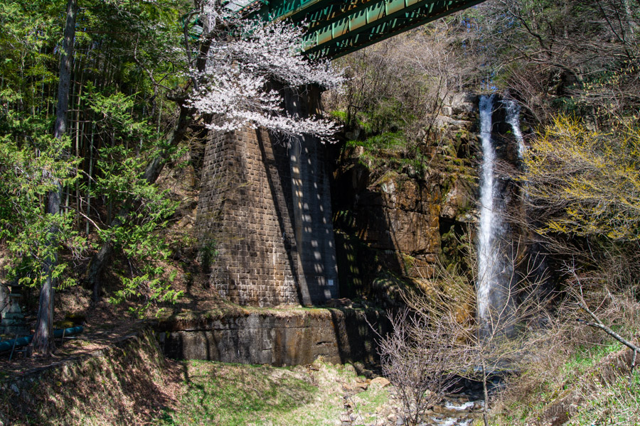
A striking waterfall that drops directly beneath a railway viaduct on the way to Kiso-Fukushima.
Frequently Asked Questions
Isn’t this information already available online?
Some of it is scattered across blogs, tourism pages, and forums – often incomplete, outdated, or focused on only part of the route. This guide brings everything together into a single, well-organised resource based on walking the full stretch in one go.
Do I need a guide to walk the Nakasendō?
Not usually. The most popular sections between Magome and Tsumago are easy to follow and can be walked independently with minimal preparation. However, once you move beyond these sections, navigation, accommodation logistics, and transport planning become more complex. This guide is designed to simplify those elements and allow you to focus on the walk itself.
How up-to-date is the information?
The route was walked in April 2026. Transport fares, bus timetables, and trail conditions are accurate as of that date. Accommodation details and logistics have been verified where possible, but it’s always worth double-checking bookings and transport ahead of your trip, particularly for smaller guesthouses.
How difficult is navigation?
Navigation is straightforward on the main historic sections, where signage is frequent. However, there are stretches – particularly on Days 2 and 3 – where the route becomes less obvious or deviates from the original Nakasendō alignment. GPX tracks are strongly recommended for these sections.
What level of fitness is required?
A reasonable base level of fitness is recommended. Daily distances range from 13 to 30 kilometres, and several stages involve sustained climbs over mountain passes. The longest day – Nojiri to Kiso-Fukushima – is demanding and best approached with an early start. The optional rail-assisted shortcuts outlined in the guide can reduce the load on longer days without missing the best sections of the trail.
Can I skip sections or do fewer days?
Yes – the itinerary is designed to be walked in full, but each day functions as a self-contained stage. The JR Chūō Line runs parallel to much of the route, making it straightforward to join or leave the trail at various points. The guide outlines the most practical options for doing so.
Can I walk this without speaking Japanese?
Yes. Basic English is understood at many accommodations, particularly in more popular post towns. That said, some smaller minshuku may require simple Japanese or assistance with booking. Learning a few basic phrases goes a long way and is appreciated.
Is luggage forwarding necessary?
Not essential, but can be helpful. Travelling light makes a noticeable difference, particularly on longer days. Some walkers choose to forward their main luggage and carry only a small day pack.
Do I need to book accommodation in advance?
For the April–May period and autumn foliage season, yes – particularly in Tsumago, Kiso-Fukushima, and Narai, which are popular with both Japanese and international visitors. Outside peak periods there is more flexibility, but smaller minshuku often have limited rooms and may not accept last-minute bookings.
Is this guide affiliated with any tour operators or accommodation providers?
No. All recommendations are based entirely on first-hand experience of walking the route. There are no affiliate links, paid placements, or sponsored inclusions of any kind.
Is it possible to camp along the trail?
Yes, with some planning – there are a small number of designated campsites along the route, though options are limited in and around the historic post towns. The guide includes notes on where camping is a realistic option and where it isn’t.
Is it suitable for solo walkers?
Yes. The route is mostly well signposted on the historic trail sections, and the guide includes GPX tracks for the stretches where navigation is less straightforward. Solo walkers should note that some accommodation options require a minimum of two guests, and the guide flags where this applies.
How busy is the trail?
The Magome–Tsumago section can be busy during peak seasons, particularly mid-morning to early afternoon. Beyond this stretch, the number of walkers drops off significantly, and it’s common to spend long periods without seeing anyone.
What time of year is best?
Spring (late March to mid-May) and autumn (October to mid-November) are the most popular seasons and offer the best conditions for walking. Summer is hot and humid and not really recommended. Winter is possible but some facilities close and higher passes can be snow-covered.


What a fantastic and comprehensive resource – well done David. I’ve done sections on day trips but now I’m tempted to do the 5 day through walk. Given the number of foreign tourists walking in Japan these days this should generate a lot of interest.
Thanks a lot for the comment and for reading, Phil.
I think this would definitely be up your alley – if you’ve already enjoyed a few day sections, the full five-day walk is well worth committing to. It’s quite varied, and the post towns feel very different from one another.
And yes, with the growing interest in walking holidays in Japan, hopefully more people will discover just how special the Nakasendo is.
This is a fantastic resource, hats off for producing it. You’ve (deliberately?) left out arguably the best section around 瑞浪 / 細久手宿 where the ambiance of the old road can be enjoyed. . .
Thank you – glad it’s been useful. The guide focuses specifically on the Kiso Valley section (Nakatsugawa to Shiojiri), so the Mizunami–細久手宿 area falls outside its scope. That said, it’s one of the finer stretches of the whole Nakasendo, and there’s a good chance it’ll feature in a future instalment.
Got it.. was just curious. I’ve walked it 20+ times as a guide….. and never seen a bear !