A Pocket Guide for Climbing Mt Fuji in 2026 Hot on the heels of the Japan Hiking Field Guide comes its first companion: a pocket reference built for one mountain and one mountain only. If you’re climbing Mt Fuji this season, this pocket guide is...
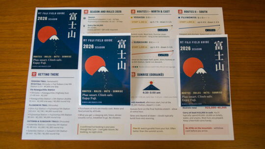
A Pocket Guide for Climbing Mt Fuji in 2026 Hot on the heels of the Japan Hiking Field Guide comes its first companion: a pocket reference built for one mountain and one mountain only. If you’re climbing Mt Fuji this season, this pocket guide is...
Hiked on June 12, 2026 . Asama-sanso 浅間山荘 – Asama-kazankan 火山館 – Mt. Maekake 前掛山 Duration: 2 days Distance: 22.3 km Elevation change: 1320 metres Highest point: 2524 metres Start: Asamayama tozan-guchi bus stop Finish: Asamayama tozan...
Hiked on Sep 21, 2025 . Kamikochi 上高地 – Dakesawa 岳沢小屋 – Karasawa Cirque 涸沢カール Duration: 3 days Distance: 26.7 km Elevation change: 1685 metres Highest point: 3190 metres Start: Kamikochi Bus Stop Finish: Kamikochi Bus Stop Difficulty:...
Hiked on Aug 23, 2025 . Kitazawa-toge 北沢峠 – Choei-goya 長衛小屋 – Ko-senjogatake 小仙丈ヶ岳 Duration: 7 hours Distance: 11 km Elevation change: 1003 metres Highest point: 3033 metres Start: Kitazawa-toge Finish: Kitazawa-toge Difficulty: ...
Hiked on Jul 24, 2025 . Shinhotaka Ropeway 新穂高ロープウェイ – Yarigatake 槍ヶ岳 – Kamikochi 上高地 Duration: 3 days Distance: 35.2 km Elevation change: 2090 metres Highest point: 3180 metres Start: Shinhotaka Ropeway bus stop Finish: Kamikochi bus...
Hiked on May 20, 2025 . Karasawa Junction 涸沢分岐 – Hanadate 石楠立 – Mt. Banjiro-dake 万二郎岳 Duration: 5 hours Distance: 9 km Elevation change: 366 metres Highest point: 1,406 metres Start: Amagi juso tozanguchi Bus Stop Finish: Amagi juso...
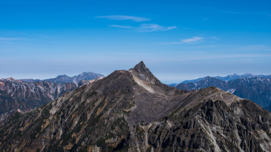
Enter Naka-Shirane-san et al. TL;DR Not all 3,000-metre mountains in Japan are officially recognised. Peaks like Naka-Shirane-san and Gendarme lack prominence and are classified as secondary. Cultural factors and quirks, such as Fuji’s lesser-known...
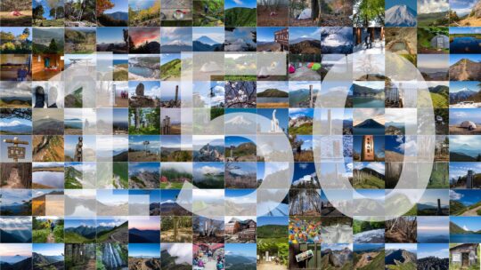
The Trail Less Rushed: 150 Hikes Quietly, last month I marked a major milestone: my 150th hiking trail guide on RIDGELINEIMAGES.com! Over the past 12 years, creating these trail guides has been a labour of love. While they make up less than half of...
Hiked on September 24, 2024 . Ojiragawa Gorge 尾白川渓谷 – Shichijo-koya 七丈小屋 – Komagatake Shrine 駒ヶ岳神社 This is a long and demanding hike, suitable for experienced hikers. Do not attempt the Kuroto Ridge course unless you are comfortable climbing...
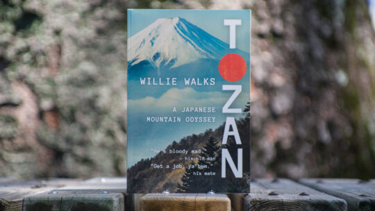
One Man’s Quest for the 100 Best Mountains in Japan It comes with much excitement and anticipation when a book about hiking in Japan is released, whether it’s a guidebook or a memoir. Such books are rare finds. As soon as I heard that William...

July 21st to July 27th, 2024 . Murodo 室堂 to Shin-Hotaka Ropeway 新穂高ロープウェイ This is a long and demanding multi-day hike suitable for experienced hikers. Do not attempt this hike unless you have experience in route-finding. Carry the relevant...
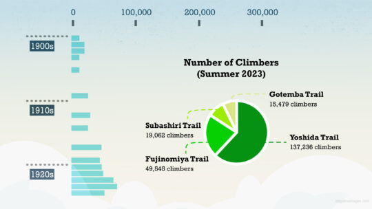
Stemming the Endless Tide on Fuji-san Even when shrouded in rain, Mount Fuji retains its magnetic charm, as evidenced by the throngs who dared to climb it in 2017, a year when Tokyo recorded a staggering 21 consecutive days of rain in August. This...
Hiked from July 21 to July 29, 2023 . Hirogawara 広河原 to Akaishi Onsen Shirakabaso 赤石温泉白樺荘 This is a long and demanding multi-day hike suitable for experienced hikers. Do not attempt this hike unless you have experience in route-finding. Carry the...
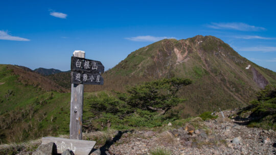
Hiked on Jun 17, 2023 . Mt. Mae-Shirane 前白根山 – Midaga Pond 弥陀ヶ池 – Mt. Goshiki 五色山 Duration: 8 hours Distance: 13.3 km Elevation change: 1098 metres Highest point: 2578 metres Start: Nikko Yumoto Campground Finish: Nikko Yumoto Campground...
Celebrating 10 Years Blogging in Japan This month, RIDGELINEIMAGES.com celebrates its 10th anniversary. For a decade now, I’ve been snapping pictures, sharing my hikes, adventures, gear selections, and how-tos. It’s hard to believe I’ve been...
100 Things You Should Know About Hiking Japan In spite of the fact that blogging is often thought of as a solitary pursuit, most of us count on the support, wisdom, and good deeds of others to cobble things together. This blogger included. I don’t...