.
Hyakuhiro Waterfall 百尋の滝 – Mt. Kawanori 川苔山
Distance: 12.6 km
Elevation change: 933 metres
Highest point: 1363 metres
Start: Kawanori-bashi bus stop
Finish: Hatonosu Station (Ome Line)
Difficulty: ▅▅▅▅▅▅▅▅▅▅ ❸
Map: Yama to Kogen Chizu 山と高原地図 [No.25 奥多摩 OKUTAMA]
GPX TrackKML TrackGSI MAPPDF Topo Map
Near Perfect Weather for Climbing One of Okutama’s Finest
It’s been a work in progress, but I finally got around to knocking off the last big mountain in Okutama – Mt. Kawanori. Last year, I made it as far as the Hyakuhiro Waterfall until heavy mist and light rain put an end to any summit attempt, so with near perfect spring weather, it was time for another bid. Access to the trailhead involves taking a train to Okutama Station and a 13-minute bus ride (bus stop 1 Higashi Nippara 東日原行) get off at the Kawanori-bashi 川乗橋 bus stop (290 yen). Be warned, though; this mountain sees a fair share of foot traffic on weekends, and I count myself lucky to have squeezed onto the additional bus that rolled up, with those less fortunate told to wait for 40 minutes.
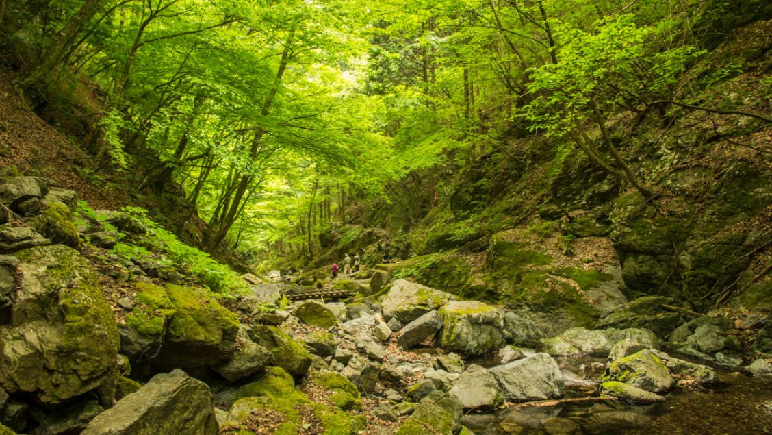
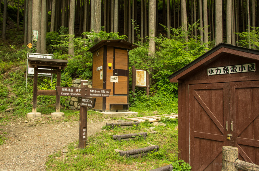
From the Kawanori-bashi bus stop, walk along the Kawanori Forestry Way for 35 minutes to the first rest stop, where you’ll find a local area map and a toilet. The landslide damage from last summer had been repaired, giving a welcome reprieve to walking along the bitumen. Note that from here on, sections of the trail that rise above the river are quite exposed, so take extra care with your footwork. From the first rest stop, it takes around 50 minutes to reach the strikingly beautiful Hyakuhiro Waterfall, making it a fine spot to relax and take in the 40-metre-high cascades.
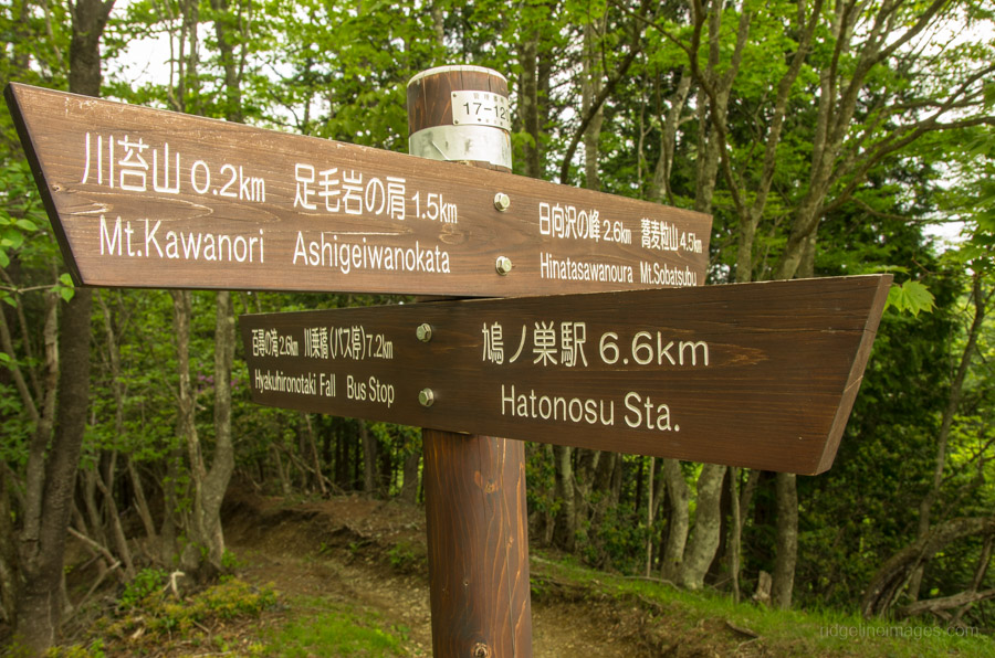
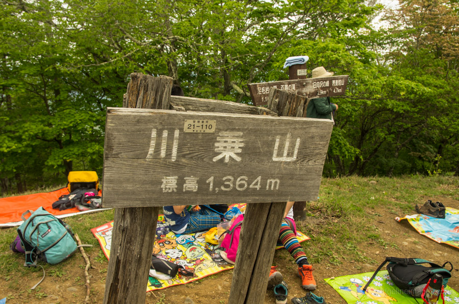
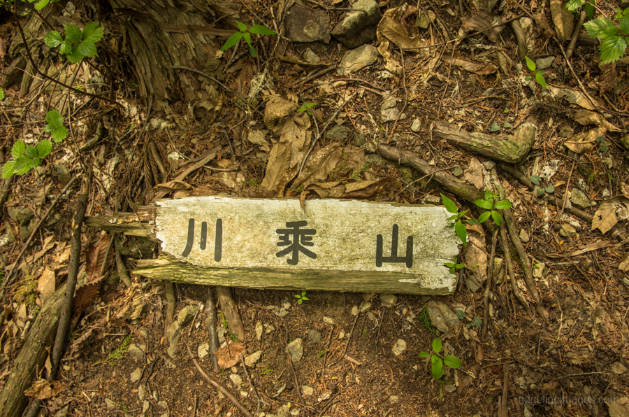
When you’re ready to head off, retrace your steps back up the wooden steps and prepare yourself for a solid 100 minutes of steep climbing to reach the summit. The first part of the trail shows up as a hazard marker on the map, and climbing ropes have been added at some locations. After dipping back down to a small creek, the trail splits a little further along. The trail heading straight is less used and calls for a demanding climb to the summit, while the trail on your left is more commonly trodden and better kept up. Before you reach the true summit, the trail pops out at a saddle, and from here, a wide path meanders its way to Mt. Kawanori 川苔山 (1,363 m). When I arrived at the summit, there was barely a square inch of earth to sit down with the crowds, more akin to a cherry blossom festival than a quiet mountain retreat.
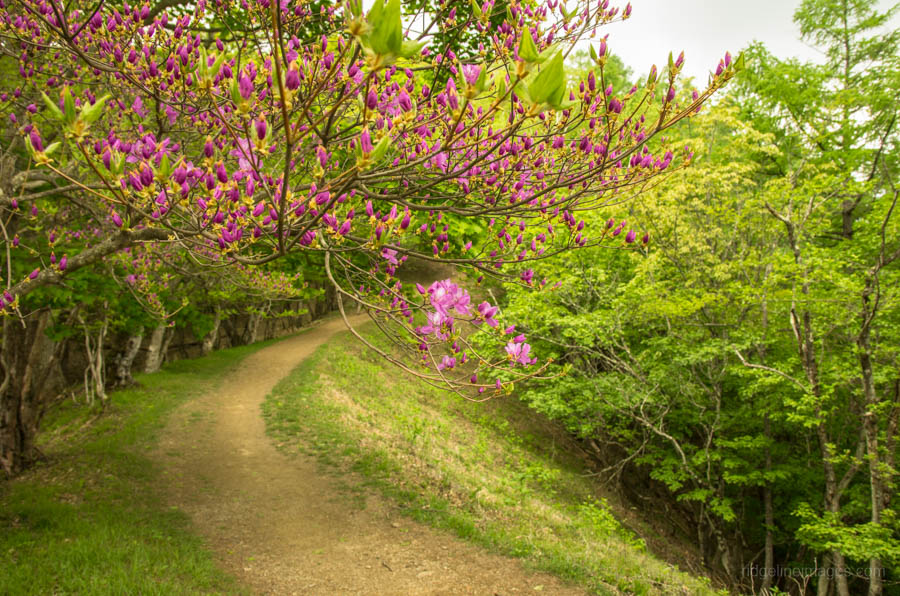
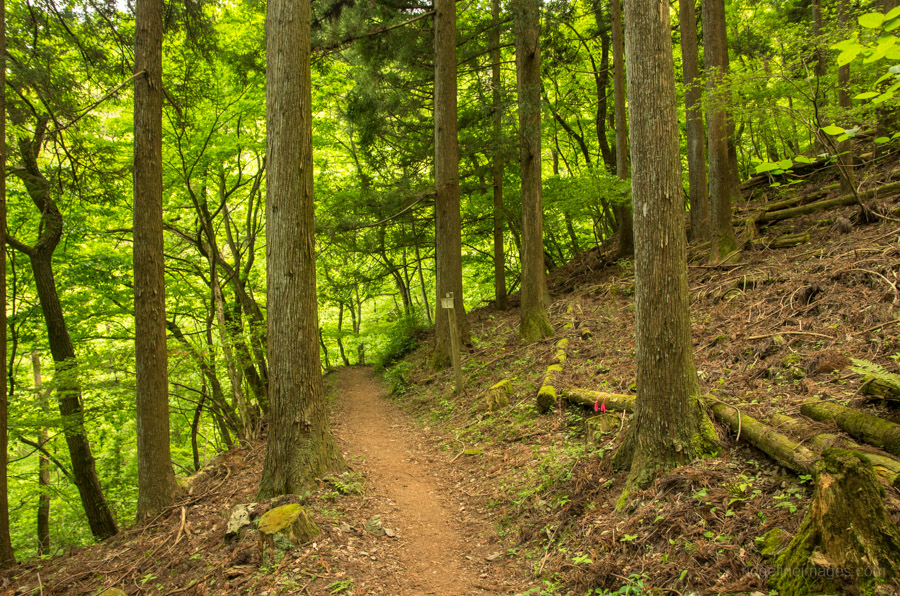
If the summit is crowded, a better bet is to eat near the saddle junction. For the return journey, look for the sign pointing towards Hatonosu Station 鳩ノ巣駅 (6.6 km). This trail unfortunately doesn’t hold a candle to the path heading up and, for the most part, ambles its way through plantation forests. The path is also quite rocky, which doesn’t help.


Thanks for the great hike suggestions. Here are some additional comments:
When I arrived at Okutama, there was no bus for more than an hour (they are very rare), so check the bus schedule before going. We took a taxi which is about 1600 Yen.
The way back is very long and takes almost 3 hours. It has a steep part, then a long flat part which is pleasant to walk, and then another steep part.
Thank you for the post, I used it as a guide.
I had to take taxi to Kawanori-bash as well but I wasn’t able to find one. Later it somehow appeared near the railway station.
Ascent took 3 hours, descent 2 hours(I tried to be quick to make it before sunset).
Waterfall was an amazing place to have rest.
At the Hatonosu station you can refill your water for free.
You set a good pace on the way back down. Nice to know about the free water available back at the station.
Hello! Thank you for this site. It’s very helpful.
Regarding this route, would you discourage walking it in reverse. There’s a good brewery around
Okutama station I’d like to finish at.
Thanks for your comment and question. The only issue I can think of is you’ll need to plan your return to coincide with the bus as they are infrequent. Also check the Mt. Honita hike for directions heading up the first section of trail from Hatonosu Station.
I tried to do this hike today (7 January, 2020) — Okutama Station to Kawanori to Hatonasu Station route. Please be advised that due to the Hagibis typhoon in Oct. 2019, the bus from Okutama Station to Kawanori Bashi trailhead is CANCELLED. At bus stop #1, outside Okutama Station, there was a message in kanji (sorry, no English) to say as much. Under was a picture of a portion of the bus route road where both lanes had fallen away, leaving the road unpassable. It has not been repaired yet. If you want to do the hike, you still can, but you go from Hatonosu Station and back the same route, or Hatonosu Station — Mt. Kawanori — Korii Station.
I’ve seen pictures of where the road has washed away effectively isolating the Nippara Limestone Cave and surrounding community. According to the cave’s Facebook page it won’t be repaired until April 2020.
Did this on Tuesday (a national holiday) 11 Feb., 2020. As the Kawanori Bashi trailhead is currently inaccessible (see my previous comment on this thread), I did Hatonosu Station — Mt. Kawanori — Hatonosu Station. Very pleasant hike, with only a smattering of snow near the top of Kawanori. Great winter views of Fuji, and only a handful of hikers all day. Some routes have been closed off from the summit into the hinterlands. Some bear warning signs, but this being winter, less risk. A great time to climb this mountain.
I hiked this route (3 October 2020) so some updates. There is still a lot of damage to the road, but the bus from Okutama is now in operation. However, it does not stop at Kawanori-bashi. The hiking trail from this entrance is officially closed. Should you wish, you can take the bus to the next stop, and walk back down to Kawanori-bashi and go through the roped-off entrance. Some hard-hat wearing forestry workers we met on the way kindly warned us not to continue. There are sections that appear to have been recently repaired with new wooden bridges and ladders. It is hikeable, but proceed at your own risk. We saw about a dozen other hikers on the whole trail, most of whom seem to have taken the Hatonasu Station route. We took that path down, and it is as unremarkable as described. Round trip was 5 hours.
Helpful information. Good reminder for me to put up a note that the trail is officially closed.
Hi all – an update on the trail, it has now been officially reopened following its year-long closure after Typhoon Hagibis. The local authority has put in some serious work to improve bridges in the section leading to Hyakuhiro Waterfall, as well as additional chains in the section leading to the summit.
I do this hike at least once a year and it’s in the best condition I’ve seen in a while and is well travelled. Definitely recommend a swim at the watering hole at Hatanosu once you’re finished hiking – best way to end a hot summer hike!
Beautiful work Michael and I second that taking a dip at Hatanosu a well-deserved treat at the end!
Hi All , Okutama website is showing that Trail from Bridge is still closed.
Okutama visitor center Info https://www.ces-net.jp/okutamavc/info/52
Planning to visit next week. can someone reconfirm who recently visited
Hi would like to know if it’s possible the same ..
don’t understand if still close or already reopened
As the trail from the bridge will likely be cordoned off until July your best option would be starting from Hatonosu Station and following the descent route. From the summit you can circle around and finish at Kawai Station. Less advised would be starting from Okutama Station and hiking up via Mt. Honita as the trail is steep and not well maintained.
Hi, sorry? Do you know if it is still close? I want to do it this weekend… Thanks!
Access from the Kawanori-bashi bus stop won’t be possible until sometime next month. As above you can still climb Kawanoriyama via Mt. Honita from Okutama Station or alternatively set off from Hatonosu or Kawai stations.
I don’t understand well ..
So if if I start from kawanori bashi bus , walking through the haykuiro waterfall, I cannot reach the summit of mt kawanori??
So the trail is still not opened??
Hi Alessandro, sorry for the confusion. The trail from Kawanori Bridge to Mt. Kawanori has now reopened.
Thanks so much for the informations!!
Hi David!
I just want to ask if Mt. Kawanori is open on April 22 and is it safe to hike alone? Thank you!
Hi Madonna.
From March 6–26, 2023, the Kawanori Forestry Way is undergoing repairs and will be closed. However, when you plan to hike, it will be open. As a popular mountain, the route to Mt. Kawanori is generally well signposted and easy to follow. If you intend to hike alone, it’s always better to do it on a weekend where there are more people around in case you have any trouble.
This is a really great hike. One of my favorites so far. The variety of environments you can experience makes each section of the hike thoroughly enjoyable. From the waterfalls, creeks, forests, bridges and not to mention the fantastic views. The length and steepness of the hike makes it quite challenging and very enjoyable!
Hiking at the end of October last month, the trail was covered in the autumn leaves which made some of the narrow sections on the way up a little slippy and hazardous. Hiked on a weekday to avoid the weekend crowds which proved successful as we saw about ten people all day. I would say that this hike might prove a little too much for non-experienced hikers or people without some strength or stamina as the length of the route and its steepness in places will soon make you tired. For those inexperienced hikers I might suggest hiking as far as the waterfall and returning to the trailhead to catch the bus back (if there is one?). Continuing past the waterfall means making a commitment. Depending on your fitness that means roughly five or more hours of hiking which soon tired out my ‘experienced’ hiking partner. As a result we hiked down in darkness (yes, it took two hours more than expected due to their fitness and the amount of equipment they brought with them).
There are sections of the trail which are not so clear and require searching for ribbons attached to trees. I would recommend inexperienced hikers to avoid this hike if visibility is poor as it would be quite easy to veer from the trail, slip or lose track of their partner.
Finally, avoid doing the hike in reverse. Descending the opposite way down has proven to be very dangerous with a quick Google search showing people sometimes losing their life. (There are often steep, narrow sections with sheer drops). Follow the trail up the recommended route from the Mt. Kawanori Trailhead. Don’t start from Hotonosu Sation. Overall, a challenging and enjoyable hike. Thanks always to David for this site. It’s always my go to source of information for hiking when I have the time! Keep up the amazing work!
Thanks so much for sharing this, Michael! Your tips about the trail conditions and advice for less experienced hikers are super helpful, as is the reminder to stick to the recommended route—I hadn’t realised how hazardous the reverse route could be.
Hi David,
My wife and I just took the hike and I must say it was gorgeous. One of the most scenic routes near Tokyo, and we have already did quite a few thanks to your website.
One thing I want to mention though is that the hike is more like 17km rather than 12.5km. It wasn’t much of an issue for us, but I thought it is something that people should be aware of.
I have used your gpx map, which indeed says 12.55km but whole hike measured with Apple Watch/iPhone showed closer to 17km and traces from both maps are virtually the same.
Nonetheless, it’s my first comment on you website and I want to use that opportunity to thank you for all your hard work, providing those SUPERB guides for people!
Hi Michal,
Many thanks for the feedback about the website. I’m pleased to hear that you and your wife enjoyed the hike. It really is one of the best hikes near Tokyo, especially during this time of year. I have visited the Hyakuhiro Falls several times and always marvelled at them.
One reason you might find a difference between your distance and the one uploaded to this blog is that after each hike, I ‘clean up’ my GPX route to make my hike data more accurate. If you take a look at the same route listed by Yamap, it also indicates a similar distance https://yamap.com/model-courses/61. There will usually be some discrepancy depending on the GPS device used and the precise route taken.