
Japanese Mapping Nomenclature Debunked
Knowing your limits, keeping safe and out of harm’s way should be your number one priority when hitting the mountain trails and a big part of this is being able to read Japanese maps. While maps, signs and trail markers occasionally include English translations the vast majority don’t. Learning kanji doesn’t come easy for most of us so a good option is to specialise in a particular interest such as geography and mountain terminology. Eking out a good smattering of hiking kanji won’t go to waste and likely make your life easier especially when relying on your own intuitions. To help you in this quest I have brought together a glossary of key descriptions found on Japanese hiking maps along with associated topographic landforms and features.
In an earlier post I suggested getting your hands on a copy of the ‘Okutama Nature Information Map’ which provides a comprehensive overview of the Chichibu Tama Kai National Park 秩父多摩甲斐国立公園 and surrounding areas. The Tokyo Metropolitan Government – Bureau of Environment publishes a series of detailed 1:25,000 topographic maps which although primarily concern The Kanto Fureai Trail 関東ふれあいのみち are a useful accompaniment to many areas of the Chichibu Tama Kai NP. Specific map sections of the Fureai Trail are available here here. Another option are the 1:25,000 topographic maps issued through the Geospatial Information Authority of Japan (GSI) which have a good coverage of the Kanto region though perhaps a tad unnecessary. Their website I recently discovered provides free access to their entire Japan 1:25,000 map series click here. The most popular 1:50,000 maps are Shobunsha’s annually updated Yama to Kogen Chizu 山と高原地図 series which are available through large book retailers, outdoor shops and Amazon.
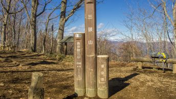
A couple of the more interesting trail markers include the 指導標 shidou-hyo and 里程標 retei-hyo. The shidou-hyo or guide posts comprise a numerical series of marked posts along the mountain trail equidistant to each other allowing you to gauge your walking pace and correspond to specific locations on a 1:25,000 topographic map. Presumably in situations where hikers find themselves in trouble these markers can allow others to pinpoint their exact location. The retei-hyo or mile-posts look like ceremonial plates often affixed to stone and are located along some walks such as the The Kanto Fureai Trail.
Some descriptions found on Japanese hiking maps
地図凡例 【ちずはんれい、chizu-hanrei】map legend
東西南北 【とうざいなんぼく、touzai-nanboku】cardinal directions “east-west south-north”
境界 【きょうかい、kyou-kai】border
等高線 【とうこうせん、touko-sen】contour line
等高線は20m間隔 【とうこうせん〇〇かんかく、touko-sen〇〇kankaku】20m contour line
標高 【ひょうこう、hyoko】elevation、altitude
現在地 【げんざいち、gen-zaichi】current location, “you are here” on a map
通行止め 【つうこうどめ、tsuko-dome】road, trail closure
通行注意 【つうこうちゅうい、tsuko-chui】road, trail requires careful attention
通行可 【つうこうか、tsuko-ka】road, trail is passable
橋 【はし、hashi】【ばし、bashi】bridge
つり橋 【つりばし、suribashi】suspension bridge
観光案内所 【かんこうあんないじょ、kanko-annai-jo】tourist information center
登山口 【とざんぐち、tozan-guchi】trailhead leading up a mountain
登山道 【とざんどう、tozan-dou】mountain trail
分岐 【ぶんき、bunki】trail branch, fork
指導標 【しどうひょう、shidou-hyo】a guide sign, signpost
里程標 【りていひょう、retei-hyo】a mile-post
ケルン 【kerun】cairn
国定公園 【こくていこうえん、kokutei-kouen】Quasi-National Park
国立公園 【こくりつこうえん、kokuritsu-kouen】National Park
日本百名山 【にほんひゃくめいざん、Nihon Hyaku-meizan】100 Famous Mountains
日本二百名山 【にほんにひゃくめいざん、Nihon Nihyaku-meizan】200 Famous Mountains
日本三百名山 【にほんさんひゃくめいざん、Nihon Sanbyaku-meizan】300 Famous Mountains
保護区 【ほごく、hogo-ku】sanctuary, reserve
関東ふれあいの道 【かんとうふれあいのみち、kanto fureai-no michi】The Kanto Fureai Trail
防火帯 【ぼうかたい、bouka-tai】firebreak
農場 【のうじょう、nojo】farm
農園 【のうえん、noen】plantation
撮影ポイント 【さつえいポイント、satsuei point】photo point of interest
展望地台 【てんぼうちだい、tenbochi-dai】lookout
歴史的建造物 【れきしてきけんぞうぶつ、rekishi-tekken-zaibatsu】historical monument
ハイキングコース 【haikingu-cousu】hiking course
初級コース 【しょきゅう、shokyuu-cousu】novice hiking course
中級コース 【ちゅうきゅう、chuukyuu-cousu】intermediate hiking course
上級コース 【じょうきゅう、joukyuu-cousu】advanced hiking course
コースタイム 【kousu taimu】course-time, duration
キャンプ場 【campu-jo】campsite
幕営禁止 【ばくえいきんし、bakuei-kinshi】camping prohibited
避難小屋 【ひなんごや、hinan-goya】refuge hut
山小屋 【やまごや、yama-goya】mountain hut
ヒュッテ 【hyutte】mountain lodge, mountain hut
ノ家 【ノいえ、no-ie】mountain lodge, mountain hut
山荘 【さんそう、sansou】mountain lodge
水場 【みずば、mizu-ba】watering hole
飲料水 【いんりょうすい、inryo-sui】drinking water
温泉 【おんせん、onsen】hot springs
トイレ 【toire】toilet
バス停 【basu-tei】bus stop
駐車場 【ちゅうしゃじょう、chu-sha-jo】car park
ロープウェイ 【ropuu-ei】ropeway
ケーブルカー 【keburu-ka】cable car
リフト 【rifuto】ski lift, chair lift
ゴルフ場 【gorufu-jo】golf course
送電線 【そうでんせん、souden-sen】power line
神社 【じんじゃ、jin-ja】神宮【じんぐう、jin-gu】Shinto shrine
寺 【てら、tera】【でら、dera じ、ji】Buddhist temple
Common landforms and features 地形【ちけい、chi-kei】
avalanche 【なだれ、nadare】
alluvial fan, delta 扇状地【せんじょうち、senjou-chi】
beach 浜【はま、hama】
cave 洞窟【どうくつ、dou-kutsu】
canyon, gorge, ravine 峡谷【きょうこく、kyou-koku】
cliff 絶壁【ぜっぺき、zeppeki】
coast 海岸【かいがん、kaigan】
cornice, overhanging snow 雪庇【せっぴ、seppi】
cove, inlet 入り江【いりえ、irie】
crag, precipice 崖【がけ、gake】
crater 噴火口【ふんかこう、funkako】
crevasse クレバス【kurebasu】
dam ダム【damu】
ditch 溝【みぞ、mizo】
embankment 土手【どて、do-te】
escarpment 急斜面【きゅうしゃめん、kyu-sha-men】
exposed rocks 露岩【ろがん、ro-gan】
foothills 麓屑面【ろくせつめん、roku-setsu-men】
forest 森【もり、mori】
glade グレイド【gureido】
gully ガリ【gari】
gully, ravine 雨裂【うれつ、uretsu】
hill 丘【おか、oka】
knife ridge ナイフリッジュ【naifu-rijyu】
island 島【しま、shima】
lake 湖【みずうみ、mizuumi】【こ、ko】
landslide 崖崩れ【がけくずれ、gake-kuzure】
limestone cave 鍾乳洞【しょうにゅうどう、shou-nyuu-dou】
marsh, swamp 沼地【ぬまち、numa-chi】
mountain 山【やま、yama】【さん、san ざん、zan せん、sen ぜん、zen】
mountain pass 峠【とうげ、touge】
mountain range 山地【さんち、san-chi】
moor 荒野【あらや、koya】
mudflow 流土【りゅうど、ryudo】
peak 岳【だけ、dake】【たけ、take】
plain 平野【へいや、yei-ya】平原【へいげん、hei-gen】
plateau 高原【こうげん、kou-gen】【たいら、taira だいら、daira】
pond 池【いけ、ike】
precipice rock 壁岩【かべいわ、kabe-iwa】
quarry 採石場【さいせきじょう、sai-seki-jou】
rapids, swift current 急流【きゅうりゅう、kyuryu】
ravine, valley, gorge 渓谷【けいこく、kei-koku】
ridge 尾根【おね、o-ne】
ridge, spur 稜【りょう、ryou】
ridgeline 尾根線【おねせん、o-ne-sen】
river 川【かわ、kawa】【がわ、gawa】
rock 岩【いわ、iwa】
rock shelter 岩のシェルター【iwa-no-sharuta】
scattered rocks 散岩【さんがん、san-gan】
scree がれ【gare】
snowfield 雪原【せつげん、setsu-gen】
snowy valley 雪渓【せっけい、sekkei】
strait, channel 海峡【かいきょう、kaikyo】
stream 沢【さわ、sawa】
stream junction 川の合流点【かわのごうりゅてん、kawa-no-goryu-ten】
summit 山頂【さんちょう、san-chou】 頂上【ちょうじょう、cho-jo】
top of, head of の頭【のあたま、no-atama】
valley 谷【たに、tani】【だに、dani】
volcano 火山【かざん、kazan】
waterfall, cascade, rapids 滝【たき、taki】【だき、daki】
wetlands 湿地【しっち、shicchi】
winding path 巻き道【まきみち、maki-michi】


Thanks for sharing this very useful information. From my perspective, the best maps I’ve found are the 1:15000 scale maps by Masuo Moriya and published by Kobito (www.kobito.co.jp) These are probably the closest I’ve found to the UK’s OS maps in terms of accuracy, detail and overall usefulness. Paths are accurately mapped, including signpost positions so it’s possible to navigate extremely precisely using dead reckoning. The level of detail is impressive without being too cluttered and the topographic information appears accurate. The map grid is already adjusted for the appropriate magnetic declination which greatly simplifies taking and walking to compass bearings. They are also printed on waterproof/tear-proof paper. The downside is that the series doesn’t appear to cover the whole country. However if you can get hold of a copy covering your intended route, I’d heartily recommend it.
Japan’s online GS map portal is excellent (http://maps.gsi.go.jp) allowing you to zoom in to very close detail. When planning a trip, I normally cross-reference my paper map with the online version to compare details and see if there is any additional useful information. However a word of caution – some of the online maps are now quite old and I’ve often found discrepancies between the marked paths and reality. Nevertheless, a very useful – and free – resource.
Thankyou so much for this, i have always wanted to create flash cards but never had the time to collect this information myself!
cheers