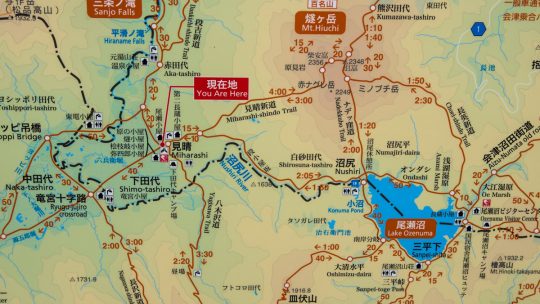
Japanese Mapping Nomenclature Debunked Knowing your limits, keeping safe and out of harm’s way should be your number one priority when hitting the mountain trails and a big part of this is being able to read Japanese maps. While maps, signs...
David grew up in the eastern suburbs of Melbourne, Australia, with hiking and outdoor pursuits being a major part of his life for as long as he can remember. He has been writing, snapping photos, and sharing his adventures on RIDGELINEIMAGES.com since 2013.
At university, David majored in environmental management and holds a Graduate Diploma of Education. He has been living in Japan for over 15 years, first in Fukushima Prefecture and now in the Tokyo Metropolis. With a love of hiking and photography, he felt the best way to combine the two was a blog to provide some inspiration for others to enjoy the myriad of trails and outdoor offerings on Tokyo’s doorstep. You can follow David on Instagram @ridgelineimages.
Japanese Mapping Nomenclature Debunked Knowing your limits, keeping safe and out of harm’s way should be your number one priority when hitting the mountain trails and a big part of this is being able to read Japanese maps. While maps, signs...
Hiked on Jan 27, 2013 Aug 23, 2023 . Mt. Sogakusan 惣岳山 – Mt. Iwatakeishiyama 岩茸石山 – Mt. Takamizusan 高水山 Duration: 4.5 hours Distance: 9.2 km Elevation change: 543 metres Highest point: 793 metres ...
Hiked on Jan 17, 2013 Aug 23, 2023 . Mt. Kobotoke-Shiroyama 小仏城山 – Sagamiko Station 相模湖駅 Duration: 4 hours Distance: 11.4 km Elevation change: 409 metres Highest point: 670 metres Start: Takaosanguchi...